If one looks for cultures that deny their’s, the pride of place must go to India, closely followed by Arabia. At least in Arabian countries’, they are proud of their latest religion while India has a masochistic pleasure in denying it’s culture and hoary past.
The Bridge at Rameswaram, one of the Holy places of Hinduism finds a mention in Ramayana, an Epic in Sanskrit by Sage Valmiki and in later Sanskrit works and regional language s of India.The bridge made of Pumice stones(?), Is mentioned to have been built by the army of Sri Rama while enroute to Sri Lanka to bring back his wife Sita who was abducted by Ravana.The island of Sri Lanka could be reached then only by crossing the Ocean.Hence a Bridge was built by stones by Sri Rama’s army. This is referred to in over hundred versions of Sri Ramayana,in many languages,other than Sanskrit and in other countries like Indonesia,Sri Lanka, Cambodia, Vietnam, and in many countries, of all places in Mexico!Temple records in Sri Ramanathaswamy temple, Rameswaram , Ancient Tamil literature including the Sangam Classics(which are at least over 20,000 years old, and ,among others in Silappadikaram,one of the Five Ancient Tamil Epics dated 16,000 years ago.)
In addition to this , temple traditions and records, not only in South India, but in North India refer to this fact There is also a temple for Sri Rama near Rameswaram,Darpa Sayanam,where Rama meditated lying on the ground as too how to cross over to Sri Lanka.
Tamil literature of yore call Rameswaram as Raman Koil,Sri Raman Koil. Read or download pdf evidence.
The sea bridge was named as Adam’s Bridge around 14th Century.
Rama Sethu
Rama Sethu BridgeRama Setu Bridge
·
·
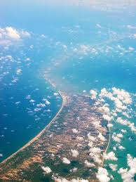
Adam’s Bridge (Tamil: ஆதாம் பாலம் āthām pālam), also known as Rama’s Bridge or Rama Setu (Tamil: இராமர் பாலம் Rāmar pālam),[1] is a chain of limestone shoals, between the islands of Rameswaram, off the southeastern coast of Tamil Nadu, India, and Mannar, near northwestern Sri Lanka. Geological evidence indicates that this bridge is a former land connection between India and Sri Lanka.
The bridge is 18 miles (30 km) long[3] and separates the Gulf of Mannar (southwest) from the Palk Strait (northeast). Some of the sandbanks are dry and the sea in the area is very shallow, being only 3 ft to 30 ft (1 m to 10 m) deep in places, which hinders navigation.[2][4][5] It was reportedly passable on foot up to the 15th century until storms deepened the channel: temple records seem to say that Rama’s Bridge was complete above sea level until it broke in a cyclone in 1480 CE.
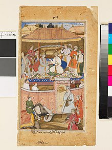
The 13th century Venetian traveller Marco Polo’s travel map shows that he travelled around the Adam’s bridge area. His travel book calls this area Setabund-Rameswara which means bridge constructed at Rameswaram. A 19th century painting depicting a scene from Ramayana, wherein Monkeys and Bears are shown building a bridge to LankaThe bridge was first mentioned in the ancient Sanskrit epic Ramayana of Valmiki. The western world first encounters it in “historical works in the 9th century” by Ibn Khordadbeh in his Book of Roads and Kingdoms (ca. 850 CE), referring to it is Set Bandhai or “Bridge of the Sea”.[6] Later, Alberuni described it.
Adam’s Bridge, also known as Rama Setu, is a chain of limestone shoals, between Pamban Island, off the south-eastern coast of Tamil Nadu, and Mannar Island, off the north-western coast of Sri Lanka.
Summary: The Council had last year in March said it would conduct an underwater exploration study to see whether the Ram Setu or Adam’s Bridge was a natural or an artificial phenomenon
With permission from the Navy, we can take our guests upto Adam’s Bridge – the sand bank between Sri Lanka and India which we approach on a dinghy because the water is so shallow.
Adam’s Bridge, also known as Rama’s Bridge or Rama Setu, is a chain of limestone shoals, between Pamban Island, also known as Rameswaram Island, off the south-eastern coast of Tamil Nadu, India, and Mannar Island, off the northwestern coast of Sri Lanka.
Connected with the subcontinent by the Adam’s Bridge, a loose group of tiny, almost invisible mountains submerged in the sea, the Sri Lankans are not particularly fond of belonging to the subcontinent.
Some experts have also expressed concern about the course tsunami waves may take if the shoals of Adam’s Bridge are dredged to make way for the navigation canal.
At the center of the controversy is “Ram Sethu” (called “Adam’s Bridge” in English), an 18-mile-long coral and limestone shoal linking Tamil Nadu in India with Mannar Island off the coast of Sri Lanka.
It was with disbelief that when I enquired, I was told that the passage between the two countries was blocked by an impassible barrier known as Adam’s Bridge, an area of shallow and treacherous sand bars with pounding seas.
of Adam’s Bridge at net ”It’s 18 songs, double vinyl, gatefold sleeve, CD and cassette.
Adam’s Bridge, also known as Rama Setu, is a chain of limestone shoals, between Pamban Island, off the south-eastern coast of Tamil Nadu, and Mannar Island, off the north-western coast of Sri Lanka.
Summary: The Council had last year in March said it would conduct an underwater exploration study to see whether the Ram Setu or Adam’s Bridge was a natural or an artificial phenomenon
With permission from the Navy, we can take our guests upto Adam’s Bridge – the sand bank between Sri Lanka and India which we approach on a dinghy because the water is so shallow.
Rama Sethu as seen from Space..
1 – 13 of 13 Posts
Remains in Dhanushkodi , Tamil Nadu
·
·
Adam’s Bridge (Tamil: ஆதாம் பாலம் āthām pālam), also known as Rama’s Bridge or Rama Setu (Tamil: இராமர் பாலம் Rāmar pālam),[1] is a chain of limestone shoals, between the islands of Rameswaram, off the southeastern coast of Tamil Nadu, India, and Mannar, near northwestern Sri Lanka. Geological evidence indicates that this bridge is a former land connection between India and Sri Lanka.[2]
The bridge is 18 miles (30 km) long[3] and separates the Gulf of Mannar (southwest) from the Palk Strait (northeast). Some of the sandbanks are dry and the sea in the area is very shallow, being only 3 ft to 30 ft (1 m to 10 m) deep in places, which hinders navigation.[2][4][5] It was reportedly passable on foot up to the 15th century until storms deepened the channel: temple records seem to say that Rama’s Bridge was complete above sea level until it broke in a cyclone in 1480 CE.
The 13th century Venetian traveller Marco Polo’s travel map shows that he travelled around the Adam’s bridge area. His travel book calls this area Setabund-Rameswara[1] which means bridge constructed at Rameswaram. A 19th century painting depicting a scene from Ramayana, wherein Monkeys and Bears are shown building a bridge to LankaThe bridge was first mentioned in the ancient Sanskrit epic Ramayana of Valmiki. The western world first encounters it in “historical works in the 9th century” by Ibn Khordadbeh in his Book of Roads and Kingdoms (ca. 850 CE), referring to it is Set Bandhai or “Bridge of the Sea”.[6] Later, Alberuni described it.
The name Rama’s Bridge or Rama Setu (Sanskrit; setu: bridge) was given to this bridge of shoals in Rameshwaram, as Hindu legend identifies it with the bridge built by the Vanara (monkey-men) army of Rama , which he used to reach Lanka and rescue his wife Sita from the Rakshasa king, Ravana, as stated in the Sanskrit epic Ramayana.
The sea separating India and Sri Lanka is called Sethusamudram “Sea of the Bridge”. Maps prepared by a Dutch cartographer in 1747, available at the Tanjore Saraswathi Mahal Library show this area as Ramancoil, a colloquial form of the Tamil Raman Kovil (Rama’s Temple)[8] Another map of Mogul India prepared by J. Rennel in 1788 retrieved from the same library called this area the area of the Rama Temple [9] Many other maps in Schwartzberg’s historical atlas[10][11] and other sources call this area with various names like Koti, Sethubandha and Sethubandha Rameswaram along with others.[12][13][14][15] Valmiki’s Ramayana attributes the building of the bridge to Lord Rama in verse 2-22-76
Adam’s Bridge (Tamil: ஆதாம் பாலம் āthām pālam), also known as Rama’s Bridge or Rama Setu (Tamil: இராமர் பாலம் Rāmar pālam),[1] is a chain of limestone shoals, between the islands of Rameswaram, off the southeastern coast of Tamil Nadu, India, and Mannar, near northwestern Sri Lanka. Geological evidence indicates that this bridge is a former land connection between India and Sri Lanka.
The bridge is 18 miles (30 km) long and separates the Gulf of Mannar (southwest) from the Palk Strait (northeast). Some of the sandbanks are dry and the sea in the area is very shallow, being only 3 ft to 30 ft (1 m to 10 m) deep in places, which hinders navigation. It was reportedly passable on foot up to the 15th century until storms deepened the channel: temple records seem to say that Rama’s Bridge was complete above sea level until it broke in a cyclone in 1480 CE.
The 13th century Venetian traveller Marco Polo’s travel map shows that he travelled around the Adam’s bridge area. His travel book calls this area Setabund-Rameswara which means bridge constructed at Rameswaram. A 19th century painting depicting a scene from Ramayana, wherein Monkeys and Bears are shown building a bridge to LankaThe bridge was first mentioned in the ancient Sanskrit epic Ramayana of Valmiki. The western world first encounters it in “historical works in the 9th century” by Ibn Khordadbeh in his Book of Roads and Kingdoms (ca. 850 CE), referring to it is Set Bandhai or “Bridge of the Sea”.Later, Alberuni described it.
The name Rama’s Bridge or Rama Setu (Sanskrit; setu: bridge) was given to this bridge of shoals in Rameshwaram, as Hindu legend identifies it with the bridge built by the Vanara (monkey-men) army of Rama , which he used to reach Lanka and rescue his wife Sita from the Rakshasa king, Ravana, as stated in the Sanskrit epic Ramayana.
The sea separating India and Sri Lanka is called Sethusamudram “Sea of the Bridge”. Maps prepared by a Dutch cartographer in 1747, available at the Tanjore Saraswathi Mahal Library show this area as Ramancoil, a colloquial form of the Tamil Raman Kovil (Rama’s Temple). Another map of Mogul India prepared by J. Rennel in 1788 retrieved from the same library called this area the area of the Rama Temple . Many other maps in Schwartzberg’s historical atlas and other sources call this area with various names like Koti, Sethubandha and Sethubandha Rameswaram along with others. Valmiki’s Ramayana attributes the building of the bridge to Lord Rama in verse 2-22-76
Adam’s Bridge, also known as Rama’s Bridge or Rama Setu, is a chain of limestone shoals, between Pamban Island, also known as Rameswaram Island, off the south-eastern coast of Tamil Nadu, India, and Mannar Island, off the northwestern coast of Sri Lanka.
27 Between which two nations does the 30-mile chain of shoals known as Adam’s Bridge
The Capability Brown landscaped grounds, and Robert Adam’s bridge over the lake, have also undergone restoration, and in years to come extensive planting will no doubt mature into something splendid.
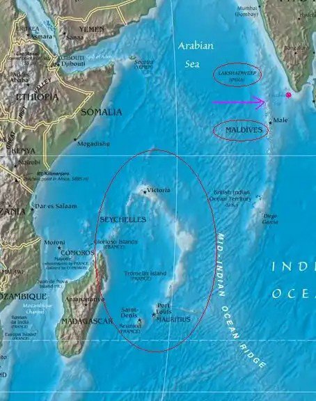
In Flores’ understanding, the “Sea of Ceylon” comprises the Gulf of Mannar, Pamban Channel, Palk Strait, and the area between Jaffna and the Mannar Channel; however, the main interest rests with the stretch of water to the south of Adam’s Bridge. The first chapter deals with the shipping routes and the rhythm of trade and traffic (“circulation”) in these areas.
The Ram Setu, also known as Adam’s Bridge, is similar to the causeway that connects India and Sri Lanka. The bridge begins from the Island of Pamban located in Tamil Nadu (India) to Mannar Island, located in Sri Lanka. This Ram Setubridge is 50 kilometers long on an approximate basis. Also, this bridge separates the Gulf of Mannar and the Palk Strait. The sea area around this setu is quite shallow, which ranges from 3 feet deep to 30 feet deep. Also, there is proof through geology that this setu was a land connection between the two nations (India and Sri Lanka). Until 1480, several scientific reports claimed that the Adam’s Bridge was constructed above sea level. But, because of the damage by a cyclone in that area, it damaged the bridge. The bridge was passable through foot until the cyclone hit that area. As per Oceanography, it is believed that the bridge is about 7,000 years old. This data tallies with the dating of carbon on the beach near Dhanushkodi and Mannar Island. https://www.squareyards.com/blog/rama-setu-adams-bridge-mnm
Rama Setu region is as intense geo-thermally as the sub-Himalayan region. This is proved by thermal wells in the southern coastline of Bharatam.
How dangerous is it to work in such a volcanic mid-ocean and create a channel passage across Rama Setu? This channel an idea was shot down emphatically by the first committee set up after Independence, Sir A Ramaswamy Mudaliar Committee, 1956 which asked that any idea of cutting a channel passage across the bridge should be ABANDONED. What could be tried, if at all, is a land-based canal across Dhanushkodi as in Suez or Panama canals.
This data was fed into the software. The results indicated that this was exactly the location of planets/stars in the noon of January 10, 5114 BC. Thus Shri Ram was born on January 10, 5114 BC (7123 years back). As per the Indian calendar it was the ninth day of Shukla Paksha in Chaitra month and the time was around 12 to 1 noontime. This is exactly the time and date when Ram Navmi is celebrated all over India.
‘. The research funded by University Grants Commission (UGC) and the Indian National Centre for Ocean Information Service (INCOIS) was carried out to know the past of the Gulf of Mannar region, which did not get affected by disasters such as 2004 tsunami. Scientists have found marine terraces which had a steeper descending slope on the seaward side near the Rameswaram islands….
Adam’s Bridge is a 35 km long stretch of shoal and sandbank under the sea between Pamban Island of Tamil Nadu and Mannar Island of Sri Lanka.
The bridge which is submerged in the water is roughly 100 meters wide and up to 10 metres in depth.
Chennai: The Adam’s Bridge, aka Rama Setu, was formed about 18,400 years ago, according to researchers from the Anna University and the Madras University, who said their study was the first of its kind done on samples taken from the drilled core surface in the depths of Gulf of Mannar off Rameswaram.
Adam’s Bridge is a 35 km long stretch of shoal and sandbank under the sea between Pamban Island of Tamil Nadu and Mannar Island of Sri Lanka. The bridge which is submerged in the water is roughly 100 meters wide and up to 10 metres in depth.
The research funded by University Grants Commission (UGC) and the Indian National Centre for Ocean Information Service (INCOIS) was carried out to know the past of the Gulf of Mannar region, which did not get affected by disasters such as 2004 tsunami. Scientists have found marine terraces which had a steeper descending slope on the seaward side near the Rameswaram islands.
Suspecting tectonic activity which could have caused the submarine landslide and vertical slopes in the region, they took samples at three places including one sample on the slope of the bridge. The water depth at the slope was 260 metres and the core sample was taken for 1.3 metres on December 12, 2015.
They looked for the microfossil called Cibicides margaritiferus to know more about the region’s past and also about the formation of the structure in the marine sediment of Adam’s Bridge.
“The microfossil Cibicides margaritiferus was almost nil up to 75 cm depth and after that, we found the fossil in good numbers. The sediments taken at the depth of 130 cm in the seabed, had microfossil around 300-350 per 10 gram”, said Professor Srinivasalu from Institute of Ocean Management, Anna University and the Principal Investigator of the project.
Since the shell-shaped fossils are rare to find on the east coast of India, scientists wanted to find out the time period of the fossils. “We knew something major had happened in that period. These fossils are also very sensitive to the climate and environmental changes and major incidents like tsunami or earthquake can wipe out its population. So, the samples were sent to US-based Beta Analytics, one of the top radiocarbon dating labs to determine the exact time period”, he told Deccan Chronicle.
The lab has determined the age of fossil using Carbon-14 dating method. The method uses organic remains of the fossil to find out the time period of its death. The results showed that the fossils found between 94 cm and 132 cm were at least 18,400 years old. The fossils in the marine sediment between 35 cm and 94 cm were 700-780 years old.
“It’s a major finding as we are one of the first groups to have scientifically got the samples from Adams Bridge. Now, it has been confirmed that the structure was formed at least 18,400 years ago,” Professor Srinivasalu said. The results also revealed that the region had a major undersea earthquake around 700 years ago.
“There were research publications indicating Indonesia and Thailand, Sri Lanka, Andaman had records of a major Tsunami and earthquake around the same time. But, there is no study that showed any quake affecting the east coast of India. This is the first study to find the evidence for an earthquake in the Bay of Bengal,” he added..
Scientists are surprised to find out the earthquake in the seismically passive Gulf of Mannar. “It was a major earthquake and tsunami happened 700 years ago and affected several countries like in 2004. It may again hit in future and we need to be prepared,” scientists said. G.Kalpana, a researcher from Anna University and Professors N.Rajeswara Rao and M.Jayaprakash from the Department of Applied Geology at Madras University also contributed to this study. Citation. Deccan Chronicle
Did Rama Destroy Rama Sethu?
And Rama awaking, called Nala unto him and said, ‘Build thou a bridge over the sea! Thou alone, I am sure, art able to do it!‘ And it was by this means that the descendant of Kakutstha’s race caused a bridge to be built that was ten Yojanas in width and a hundred Yojanas in length.And to this day that bridge is celebrated over all the world by the name of Nala’s bridge. And having completed that bridge, Nala, of body huge as a hill, came away at the command of Rama.
And while Rama was on this side of the ocean, the virtuous Vibhishana, the brother of the king of the Rakshasas accompanied by four of his counsellors, came unto Rama. And the high-souled Rama received him with due welcome. Sugriva, however, feared, thinking he might be a spy. The son of Raghu, meanwhile perfectly satisfied (with Vibhishana) in consequence of the sincerity of his exertions and the many indications of his good conduct, worshipped him with respect. And he also installed Vibhishana in the sovereignty of all the Rakshasas and made him his own junior counsellor, and a friend of Lakshmana’s. And it was under Vibhishana’s guidance, O king, that Rama with all his troops crossed the great ocean by means of that bridge in course of a month
.-Translation by Kisari Mohan Ganguly.
(Within the Mahabharata, Markandeya tells the story of the Ramayana to encourage Draupadi after Jayadratha’s attempted kidnapping of her.
Within that is a reference to the Rama Sethu which was called as Nala Sethu after the engineer in the time of Veda Vyasa.
Responding to petitioners’ argument that Ram Sethu was a place of worship and that if it was breached it would no longer be fit for worship, senior advocate Fali S Nariman said: “The scriptures say it was already broken into several pieces by Lord Rama himself after the Rama-Ravana war. If that is so, it is already broken since time immemorial and hence it can no longer be a place of worship.”
There is also a Tamil belief that Dhanushkodi,Tamil Nadu whci was destroyed by a Cyclone in 1964, means that the term Dhanushkodi means ‘ that the place was destroyed.
I am unable to find any reference in the Ramayana that Rama Sethu was destroyed.
To my understanding, Dhanush Kodi means the ‘end of Bow’, certainly no indication about it having been destroyed. And Tamil is my mother tongue.
Valmiki’s Ramayan contains graphic and poetic details of eight constellations during Hanuman’s return journey from Sri Lanka to Sunaabh Hill in the middle of the sea which apparently took about four and a half hours from 6:30 a.m. to 11 a.m. All these details of planets and nakshtras with reference to eight constellations described in…
Valmiki Ramayana, the epic that speaks of Sri Rama mentions Kavata, Kapatapuram in Tamil,and Pandya Kingdom. Kishkindha kandam also refers to Cheras,Cholas,Andhras as well
Sita threw away her Jewels as a Marker for those who would tray to trace her. The Monkeys(who later would search and Find Sita), picked up the jewel and wore them , without knowing which Jewel to wear where
World literature and Religious texts speak of the Great flood. This reference is found in Judaism, Christianity and legends of Lemuria and Atlantis. It is also referred to in the folklores of Maya’s,Incas ,Hitties,and among Australian Aborigines.
Tamil Pandyas date back to 8,00,000 years.
‘
Classic Tamil literature speaks of two Great Floods called ‘கடல் கோள்’ ‘Kadal Kol’.The reference to two floods that took place.Tamil literature records tha there was a Landmass which encompassed 49 Kingdoms, among them the three prominent ones were Chera, Chola and Pandya.The Pandya Kings established Conclave of Tamil Poets,’ தமிழ் சங்கம்’
The first one was conducted in Then Madurai,the second one was at Kavatspuram and the third one was at Madurai ( present Madurai in Tamilnadu)
Shifting of Sangam was necessitated by Great Flood.
After the first flood, capital was shifted to Kapatapuram and when Tsunami consumed it, the Sangam was held at Madurai.
Tamil texts speak of the lineage of the ancient Tamil kings of ancient Landmass
Also list of poets during the period.
World texts speak of these floods and normally these are dated around a few thousand years before Christian Era.
Periplus speaks of Kavatam. Strabo and Pliny mention among other historians of the west.
‘
Adiyarkunallar mentions that the lost land extended from Pahruli river in the north to the Kumari river in the South. It was located to the south of Kanyakumari, and covered an area of 700 kavatam (a unit of unknown measurement). It was divided into 49 territories (natu), classified in the following seven categories:
Elu teñku natu (“Seven coconut lands”)
Elu Maturai natu (“Seven mango lands”)
Elu munpalai natu (“Seven front sandy lands”)
Elu pinpalai natu (“Seven back sandy lands”)
Elu kunra natu (“Seven hilly lands”)
Elu kunakarai natu (“Seven coastal lands”)
Elu kurumpanai natu (“Seven dwarf-palm lands”)(wiki)
Many Tamil Hindu shrines have legendary accounts of surviving the floods mentioned in Hindu mythology. These include the prominent temples of Kanyakumari, Kanchipuram, Kumbakonam, Madurai, Sirkazhi and Tiruvottiyur.[8]:57–69 There are also legends of temples submerged under the sea, such as the Seven Pagodas of Mahabalipuram. The Puranas place the beginning of the most popular Hindu flood myth – the legend of Manu – in South India. The Sanskrit-language Bhagavata Purana (dated 500 BCE-1000 CE) describes its protagonist Manu (aka Satyavrata) as the Lord of Dravida (South India). TheMatsya Purana (dated 250–500 CE) also begins with Manu practicing tapas on Mount Malaya of South India.[8]:57Manimeghalai (dated around 6th century CE) mentions that the ancient Chola port city of Kavirippumpattinam (present-day Puhar) was destroyed by a flood. It states that this flood was sent by the Hindu deity Indra, because the king forgot to celebrate a festival dedicated to him.
There are refernces in Atlantis legends that the earth had an inner core populated with people.
“The first is Mother Earth’s inner crust, which is a continuation of the external surface crust. The two Polar Regions each have a large entrance or hole, somewhat like a cored apple, and the crust wraps itself down and around the mantle into the hollow interior. The outer and inner crusts have very similar topography:
Valmiki Ramayana, the epic that speaks of Sri Rama mentions Kavata, Kapatapuram in Tamil,and Pandya Kingdom. Kishkindha kandam also refers to Cheras,Cholas,Andhras as well.
This was arrived at by checking the Astronomical data.
Therefore, Tamil ,Tamil kings,Pandyas had existed at the time of Ramayana if not earlier.
So Pandya ,Tamil Kingdom dates back to 7000 years.
Yet there is another aspect to this.
While one may feel elated at the Antiquity at 7000 years, the point is Ramayana is recorded to have happened on Treta Yuga, that is about 8,64,000 years ago.Present Kali Yuga is about 5114 years old. The earlier Epoch Dwapara Yuga lasted for 8,64,000 years.
So based on this point the Ramayana is about 8,64,000 years old.
How?
The answer lies in the fact that Time is Cyclic and Non linear.
18b, 19a. vaanaraaH = oh, vanara-s; tataH = from there; yuktam = joined to – braced to the wall of fortress; hemamayam divyam = full with gold, beautiful one; muktaa maNi vibhuuSitam = pearls, gemstones, decorated with; paaNDyaanaam kavaaTam = of Paandya [kingdom’s,] castle-door; gataaH = having gone there; drakSyatha = you shall see; search inside that gateway.
“From there, on going to the Paandya Kingdome you shall see a fully golden castle-door bracing the compound-wall of the fortress, which is decorated with pearls and jewels, and conduct your search even in that kingdom. [4-41-18b, 19a]
The lineage of Sri Rama, Surya vansh,Solar Dynasty makes interesting reading for those interested in Researching Sanatana Dharma. As is known Sri Rama belongs to Solar Dynasty ,founded by Ikshvaku who was the son of Manu ,first human being. Manu also had a daughter called Ela who founded the Lemuria Empire of Chandra Vamsa. I shall write an article the importance of this fact to determine the date of Tamils. I had written about Lemuria, home of Tamils being 230 Million years old.
Now in this article let me explore the kings who preceded Sri Rama and their contemporaries.
Puthra kameshti yagnya. Rama was born after performing the yagnya
And even among these kings, let us explore one king at a time.
Mandhata. He was the Seventeenth King in the Lineage of Solar Dynasty. Sri Rama was the Fifty first in that Line.Mandhatha and Sri Rama were separated by eighteen Kings.
Ravana was a contemporary of Mandhata.( The hypothesis that there were more than one Ravana does not stand scrutiny of one checks Ramayana, Mahabharata and Purana)
Now Ravana was killed by Sri Rama .
This means Ravana was living about 3,40,000 Years before Sri Rama and Parashuram was his contemporary.
Average lifespan of Humans was, in Tretha Yuga, 10,000 years. Tretha Yuga lasts for 1,296,000 human years.
So Ravana and Parashuram preceded Sri Rama by about 3,40,000 years.
To the sceptics, it is not improbable for people to have such a long Lifespan and their technology Superior to us. I have sufficient material saved in Pinterest from credible sources to doubt our understanding of our ancient history .
And Historical Anamolies which we can not wish away with.
The information in Puranas and Ithihasas check out when one cross checks geography ,flora and fauna, and references in Regional languages like Tamil and ancient information found around the world.
‘As Mandhata grew old, he was having pride of his strength and desired to entirely conquer Swarga, the heavenly regions ruled by Indra. Indra was perturbed by this and told Mandhata that he had not completely conquered the earth. Indra told Mandhata that the Asura Lavana, the son of Madhu and Ravana, the king of Lanka were not a subject to his rule. As he knows he cannot pardon Indra’s request as his son, he goes to Madhupuri. Reference and citation. https://en.m.wikipedia.org/wiki/Mandhatri
I have written on Ramayan being history also Lord Rama being a historical figure.
I have provided proof based on,
Archaeology,
Astronomy,
Astro Archeology,
Indian and foreign literature,
Kings’ List of Sumeria which mentions Dasaratha,Rama and Bharatha as kings,
Rama’s Chapel in Ur, Iraq,
References in African legends where Rama tribe still exist,
References from Atlantis legends
And more.
Though Indian authors right from Kalidasa,Kalhana have been writing on Ramayana stating it is History, Indians tend to dismiss them because they are written by Indians!
So I am providing references from some foreign sources about the authenticity of Ramayana.
Will be sharing more.
Description by Al Biruni.
‘ Next a great bay in which Single Dib lies, i.e. the island Sarandib (Ceylon). On the coast is Ummalnara, then Ramsher (Rameshar?), opposite Sarandib; the distance of the sea between them is 12 farsakh. Between Ramsher and Setubandha 2 farsakh. Setu Bandha means bridge of the ocean. It is the dike of Rama, the son of Dasaratha which he built from the continent to the castle Lanka. At present it consists of isolated mountains between which the ocean flows...
Timeline of Indian History is staggering and unbelievable.
Ramayana,one of the two great Epics of India is now dated around 5114 BC.
The dating of Ramayana based on Astronomy ,Flora and Fauna descriptions found in the Valmiki Ramayana,pushes its date to million years.
Hindu texts mention Ramayana date to be in Treta Yuga,which is agreement with Million year dating.
The same with Mahabharata which took place around six thousand years ago,Dwapara Yuga.
The remains of Dwaraka city has been dated now at 32,000 years.
And one finds the deaths of Lord Rama and Krishna are separated by only 200 years!
But according to Purchase, these two events were separated by about a Million years!
The Indian language Tamil is dated around two thousand years ago.
The remains of the city of Poompuhar,Tamil Nadu pushes the date to 11,000 years ago.
This is based on ocean floor mapping and carbon dating.
We find Million year old Kannada Brahmi script in Karnataka.
Bengal is dated over 25000 years ,so is Thiruvananthapuram,Kerala,India.
Thiruvannamalai is dated 3.94 Billion years.
Thirupathi 2100 Million years.
The point is that all the above conclusions are based from scientific study using advanced methods and equipments in Astronomy,Geology,Infra Red ,Sea floor Mapping,Study of Glaciers and Tectonic shifts.
Yet,
If we accept these dates,then we have to discard the present history taught on Evolution,Geology and Anthropology,because during the dates mentioned as Million years the earth was hot and there could have been no life.
But more evidence compels one to rethink the present history taught.
Obviously either the world evolved much later as is being taught,or that it evolved over millions of years earlier ,as revealed by Hindu texts.
Interestingly the Age of Earth as explained in Hindu texts is accepted by Geology,that is over a three billion years ago .
The civilization called Hindu existed as found in Vedic texts.
Which is true?
One has to understand the concept of Time and the inadequacy of our Knowledge and Equipments.
Carbin dating is useless for dating objects over 50,000 years.
Infra red,Geo Mapping, Tectonic study become useless for Atomic blasts allter the atmosphere and our readings from them are fallacious.
To our knowledge ,there has been an Atomic blast in Hiroshima and Nagasaki during Second World War.
We know countries have been conducting Nuclear tests.
So the evidence from these sources are,as stated earlier, are not reliable.
So what is the truth?
This drives one to the Concept of Time.
We consider Time as Linear.
That is Time moves forward and in a straight line.
That is we have yesterday,today and tomorrow.
Can we say when a day ends and a new day begins?
We have kept 12 midnight as the end of one day and the beginning of a New Day.
Why?
If we had kept 10 am instead of 12 midnight what will happen?
Nothing.
We will be beginning the new day at 10am.
Then what happened to this 12 ‘o’ clock business?
Nothing.
It never was, nor has it disappeared.
It is only our way of understanding Time by imagining and fixing a cut off time to mark the passage of Time.
Then we have different Time Zones in the world and some Nations have more than one ,for instance the US.
Which is the correct Time?
The Time where we Live is taken as the correct Time for our Environment.
So our conception of Time is Relative.
This is the concept of Time as Linear.
In absolute terms there is no beginning for/of Time or Space.
Our Mind is not equipped to understand them as they Are.
Space and Time are the two spectacles through which we Perceive anything.
You can never think of anything without referring these,Time and Space.
So in Absolute terms Time and Space can not even be imagined.
For instance the diameter of Large Cluster Galaxies.
Their diameter is about 200 to 300 Crore Light years!
That is 3000000000* the velocity of Light!
( light velocity Kilo meters per Hour 1080 million (1.08×10⁹)!
That we can not imagine it,does not alter the fact.
So what we understand is limited.
This applies to everything in the Universe.
So what is the Truth?
Time is beginningless ,endless.
It is indescribable.
Avaktavya.
We know it is there but can not describe it.
Much less understand It.
When we Perceive,our Perception is limited to/by our senses.
We Perceive what we can.
As there are many indiduals,so are Perceptions.
But our Mind categorises different perceptions of different people,assigns a general frame of1 reference which we accept as acceptable.
This is to help the organism to Survive.
From the point of view of the individual,The Limitless Time,Time,in the view of the Perceiver,recoils Itself.
That Time is an endless cycle,a continuous Flow,
That there is no past,present and Futre.
All are either present or All are absent.
In which case what has happened,continues to happen and will happen.
So events that happened continue to happen to day and will happen in future.
In common terms ,as an example,Ramayana,if it had happened is Happening now and will Happen tomorrow.
And all of them at the same Time.
This depends on the Perceiver.
Where and how?
Quantum mechanics has just proved that,
An Atom can be present at more places than one At the Same Time,
When you Perceive a thing yoy Alter it and it Alters you,
That is one can be present at many places at the same Time.
That is the dates arrived at for Ramayana, Mahabharata and other history by Indian Texs are true.
Yet seem to be anamolies by our understanding.
This is Hindu Thought and Advaita.
Everything is Illusory ,yet at the same time Real for the Time Frame in which they are Perceived.


You must be logged in to post a comment.