Tag: Indus Valley Civilization

  • 293 Tamil Sangam Sites Vaigai River Madurai

    History of India reveals more surprises.

    Dating of these artifacts recovered from the sites is a challenge to C14,Carbon Dating, as C 14 is useleless in dating beyond 50,000 years.

    This,coupled with the systematic misinformation about Indian history by the Agenda filled western scholars(?) Straight from Max Mueller to present day pseudo researchers from the West,the self styled Secularists and Anglophiles,who try to muddle history of India and our general reluctance to study our regional and Sanskrit texts and our labelling them as myth ,without bothering to read them, has to led us to be unaware of our history.

    Keezhadi excavation image.
    Keezhadi archeological site ,Sivaganga dist. Tamil Nadu.

    And the north south divide,the canard of Aryan Invasion and the lie of Tamil and Dravidas being antagonistic to Vedic culture has made us look at Indian history in compartments,looking at Tamil culture,history as alien,against Indian/Vedic culture and treat it as inferior or later to Vedic/Sanatana Dharma.

    My researches over the past eight years prove all these assumptions  to be wrong.

    The Tamil/ Dravidian culture was a part Sanatana Dharma and existed along with it.

    It predatess Sanatana Sanatana Dharma, going by the findings of archelogical sites.

    For example there are,

    A million year old Advanced Tamil site in Chennai,

    In Thiruvallur,

    20,000 year old Poompuhar site in Tamil Nadu with Vedic Links,

    Sites near Palani,Andippati,Adichanallur,……..

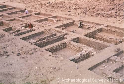
    Now Kezhadi,in Sivaganga District,near Madurai has revealed a river civilization beneath the ground.

    And it belongs to Sangam Era.

    Sangam Era is currently dated around 3000 years ago!

    Yet Poompuhar is around 20,000 years old.

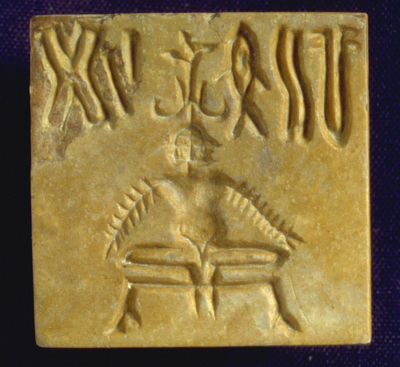
    Tamil Brahmi is older than this,as Cilappadikaram, a Classical Epic of Sangam Era was written, not in Brahmi, but in evolved later Tamil!

    Archeologists have, in 2013, have catalogued 293 towns belonging to Sangam Era in Vaigai bed!

    Time we rewrote our History.

    In a year-long survey conducted in 2013, the state Archaeology department had identified nearly 293 Sangam Age towns along the course of river Vaigai. “Our field of research included areas that fell within five kilometres from the river on both the banks, starting from the place of Vaigai’s origin in Theni district to the very end of the river in Ramanathapuram district,” says archaeologist Dr. V. Vedachalam. The places were classified as granaries, trading points, ports, habitation sites and living or dilapidated temples. Excavations were carried out at Varushanad in Theni and Azhagankulam in Ramnad.

    The excavation at Keezhadi has been carried out at two localities in the farm. “Both the places have yielded different items and we presume they represent a social hierarchy,” says Amarnath. The bigger of the two locations with more number of trenches is said to be a settlement of educated rich people, as many jewellery, fine game stones, semi-precious stones and a dozen Tamil Brahmi inscriptions have been found. “Even the brick structures appear more refined.” Beads of agate, Carnelian and quartz indicate that they had trade link with countries like Rome. The Tamil Brahmi letters found on pottery is all names of individuals such as, Thisan, Aadhan and Udhiran. “They are typical Sangam Age Tamil names,” says Amarnath.

    Reference and citation.

    http://www.thehindu.com/features/metroplus/society/keezhadi-archaeological-excavation/article7557728.ece

  • Indus Valley Seal Man Yogic Posture Dates Patanjali Yoga Tamil 9000 BC

    Indus Valley Seal Man Yogic Posture Dates Patanjali Yoga Tamil 9000 BC

     I came across a Harappan Seal, showing a Male figure seated in a Yogic posture.

    This posture is Moolabhandasana.

    A posture where the body from the anus to the navel is contracted and lifted up and towards the spine.

    The Indus Valley Civilization.

    The Indus Valley Civilisation (IVC) was a Bronze Age Civilization (3300–1300 BCE; mature period 2600–1600 BCE) mainly in the northwestern regions of South Asia,extending from what today is northeast Afghanisthan Pakistan and northwest India.

    Moolabhandaasana. Shown in Featured Image.

    ‘ Square seal depicting a nude male with three faces, seated in yogic position on a throne, wearing bangles on both arms and an elaborate headdress. 

    Five symbols of the Indus script appear on either side of the headdress which is made of two outward projecting buffalo style curved horns, with two upward projecting points. A single branch with three pipal leaves rises from the middle of the headdress.

    Seven bangles are depicted on the left arm and six on the right, with the hands resting on the knees. The heels are pressed together under the groin and the feet project beyond the edge of the throne. The feet of the throne are carved with the hoof of a bovine as is seen on the bull and unicorn seals. The seal may not have been fired, but the stone is very hard. A grooved and perforated boss is present on the back of the seal.'( description by harappa.com)

    The posture is an advanced technic of Yoga Asana,Posture in the practice of Yoga.

    This posture in Yoga is called Moolabandhaasana.

     (A posture where the body from the anus to the navel is contracted and lifted up and towards the spine.’)

     Here is the demo.

    Moolabhandaasana. Image.
    Moolabhandaasana, A Yoga Posture.

    The name can be translated from Sanskrit as the root lock, since mula (or moola) means ‘root’, and bandha – ‘lock’. This is an external meaning. The internal or deeper meaning is that mula or the root is the source of energy for our body, and through the practice of this bandha we can gain a certain amount of control over this energy. The benefit of such control is the substantial decrease or even total elimination of bodily ailments along with the increase of the vital energy. This is the subtle meaning of mula bandha.

    Patanjali’s Yoga sutra is dated 400 CE.

    This posture Moolabhandasana is found in Harappan Seal dtd about 3300–1300 BCE; mature period 2600–1600 BCE.

    The cuture on the banks of Saraswathi is about 10,000 years old,that is is about 8000 BC.

    The date of Indus valley civilization may based on this Harappan site.

    The Rig Veda is to be dated around 9000/10,000 yearscago ago,based on the date of River Sarasvati.

    Please read my previous article.

    If  one finds the Moolabandhasana posture in 8000 BC or 10,000 years ago,how can one assign the date Yoga Sutra of Patanjali at 400 CE?

    And this Yoga has been in vogue in the south of Vindhyas in India and was based on Yoga Sutras.

    This means that the south was very much in tune with Sanatana Dharma and was a part of Sanatana Dharma.  

    As Patanjali is one of the Eighteen Siddhars of Tamil, it can be postulated that Yoga and Sanatana Dharma was present in the South,Dravida Desa at the time of Rig Veda and the Sarasvati River in full flow.

    Which means that the Dravida culture is at least 10,000 years old as Sarasvati River and The Rig Veda are dated around the same time.

  • Rig Veda 11,000 Years Old. Sarasvati River Research Satellite Images Dhola Vira Site

    Rig Veda 11,000 Years Old. Sarasvati River Research Satellite Images Dhola Vira Site

    The findings by Remote SensingAgency,Hyderabad,India,Computer simulation of Indian coast line and by National Institute of Oceanography,India, studied together make a startling revelation.

    The Vedas,contrary to what is being informed,is, are at least 10,000 years old.

    It is found,by simulation of flood in India,by Dr.Milne of Durham University that the land mass off the coast of Cambay,Gujarat,India,might be between 9000 and 12,000 years old.

    To understand this better one should know that the date of Indus Valley civilization,must be dated back fom the present,500o years ago concept ,which was based on the debunked Aryan Invasion theory..

    (I have written on the Fraud called Aryan Invasion.Shall be writing more on this.)

    The civilization was so advanced that it could be dated back in time.

    The answer lies in Dhola Vira,Rann of Kutch,Gujarat,India.

    Dhola Vira is dated, at least, about 4,500 years ago,according to Archeologist Sri. Bisht

    The well deveoped structures and advanced water storing wells indicate a civilization which has been there for quite sometime.

    The answer lies in the river Saraswathi.

    River Sarasvati.image
    Sarasvati River,India,Satellite Image.

    According to Sri. Gupta, Remote Sensing Agency,Hyderabad,India,the Saraswathi River flowed from the Himalayan Galciers through Gujarat and joined the Arabian Sea in Gujarat.


    The river was 22 km wide!

    It flowed in Parallel to River Indus( Sindhu)

    This was found from the Satellite Images.

    And based on the melting of Himalayan Glaciers,Saraswathi River had flown between 10000 and 6000 years ago.

    Saraswati River Satellite images
    Saraswati River Satellite images

    Read this research paper in Nature.

    Punjab Rivers Satelite images
    Punjab Rivers Satelite images

    ‘The lost Saraswati River mentioned in the ancient Indian tradition is postulated to have flown independently of the Indus River into the Arabian Sea, perhaps along courses of now defunct rivers such as Ghaggar, Hakra and Nara. The persistence of such a river during the Harappan Bronze Age and the Iron Age Vedic period is strongly debated. We drilled in the Great Rann of Kachchh (Kutch), an infilled gulf of the Arabian Sea, which must have received input from the Saraswati, if active. Nd and Sr isotopic measurements suggest that a distinct source may have been present before 10 ka. Later in Holocene, under a drying climate, sediments from the Thar Desert probably choked the signature of an independent Saraswati-like river. Alternatively, without excluding a Saraswati-like secondary source, the Indus and the Thar were the dominant sources throughout the post-glacial history of the GRK. Indus-derived sediment accelerated the infilling of GRK after ~6 ka when the Indus delta started to grow. Until its complete infilling few centuries ago, freshwater input from the Indus, and perhaps from the Ghaggar-Hakra-Nara, probably sustained a productive marine environment as well as navigability toward old coastal Harappan and historic towns in the region.’

    * ka), a unit of time equal to one thousand (103) years.

    The above is an abstract of conclusions in a paper in Nature.

    Author information.

      • Nitesh Khonde

      Present address: Birbal Sahni Institute of Palaeosciences, Lucknow, 266007, India

    Affiliations

    1. Department of Geology, The M. S. University of Baroda, Vadodara, 390002, India

      • Nitesh Khonde
      • , D. M. Maurya
      • & L. S. Chamyal
    2. Physical Research Laboratory, Navrangpura, Ahmedabad, 380009, India

      • Sunil Kumar Singh
      • & Vinai K. Rai
    3. Geology and Geophysics, Woods Hole Oceanographic Institution, Woods Hole, USA

      • Liviu Giosan
      • Source of the article wanted above.

    https://www.nature.com/articles/s41598-017-05745-8

    ThecRig Veda,one of the earliest of the four Indian texts mentions Saraswathi repeatedly.

    • The Sarasvati is praised lavishly in the Rigveda as the best of all the rivers: e.g. in RV 2.41.16

    अम्बितमे नदीतमे देवितमे सरस्वती अपरास्तस्य इव स्मासि प्रशस्तिम् अम्ब नास्कृतिम्

    • Oh Mother Saraswati you are the greatest of mothers, greatest of rivers, greatest of goddesses. Even though we are not worthy, please grant us distinction

    Other verses of praise include RV 6.61.8-13, RV 7.96 and RV 10.17. In some hymns, the Indus river seems to be more important than the Sarasavati, especially in the Nadistuti sukta. In RV 8.26.18, the white flowing Sindhu ‘with golden wheels’ is the most conveying or attractive of the rivers.

    • RV 7.95.2. and other verses (e.g. RV 8.21.18) speak of the Sarasvati pouring “milk and ghee.” Rivers are often likened to cows in the Rigveda, for example in RV 3.33.1,
    Like two bright mother cows who lick their youngling,
    ( source of the Quote.

    https://en.m.wikipedia.org/wiki/Sarasvati_River

    So Rig Veda can be dated at 10,000 Years ago.

    Featured image of Dhola Vira Well. Wiki.

  • Indus Valley Civilization Dravidian

    Indus Valley Civilization Dravidian

    ..The term Dravidian coined by Robert Caldwell,who was a Christian Missionary with the Agenda of propagating Christianity much like Mueller has played/is playing havoc in understanding the ancient History of India.

    The term Dravida was used by the Vedic texts to indicate a group of people living south of the Vindhya Mountains,Caldwell used this term to indicate an Ethnic group and paved a way to divide India on the bass of Ethnicity.

    Then came the sophisticated attempt of dividing my proposing Aryan Invasion theory,which now stands discredited.

    Please read my post The Fraud called Aryan Invasion.

    While Max Mueller ,another well masked missionary took the route of planting deliberate misinterpretation of Vedas,though he did some good job,to confuse ancient Indian History(please read my articles on Max Mueller),Robert Caldwell took the Tamil Language to distort History by paving the way for misinformation about Tamils,Dravidas and Sanatana Dharma.

    Indus valley time chart.image.
    Indus valley Timeline

    This has made historians running in circles.

    If one accepts Aryan Invasion Theory,you have to accept that there was no presence of Vedic Dharma in the south;there were animosities between the Arynas and the Dravidas:the culture of these two were mutually exclusive;you can not explain the advanced culture in the South nor can you account for the numerous archeological finds that indicate a close connection between the two:you find it to date Kings and Eras.

    But facts reveal themselves if one takes India as a unit refer to literature of All Indian Languages and foreign  literary references about India from Plato,Strabo and others.

    The facts.

    Rama’s ancestor was A Dravidian and ruled Dravida Kingdom.

    Ravana was from the south and was a Dravida.

    Shiva worship preceded in the Dravida Desa much before the Vedic period.

    Valmiki,who compiled/composed Ramayana,was a Tamil poet.

    So were Sage Agastya ,Parashurama,Gautama,Rishyasrunga….

    Rama’s ancestor Sagara of Kosala Kingdom married a Dravidian princess.

    Krishna attended Tamil Sangam.

    Krishna,Arjuna married Pandyan Princesses and had children.

    Sahadeva and Balarama visited South in their pilgrimage.

    Madurai Meenakshi’s father Malayathdwaja Pandyz fought along with Pandavas in the Kurukshetra battle of Mahabharata.

    Chera king Perunchotru Udiyan Neduncheralaathan provided food for both the Pandava and Kaurava armies during Mahabharatha war.

    Kulothunga Chola’s son in law built Konark Sun Temple.

    Rama,Sita and Hanuman ,among others of Ramayana visited many Shiva and Vishnu temples in the south..

    List is endless.

    Now more evidence.

    Tamil Brahmi script was found in Saraswathi valley.

    Tamil King Sibi,ancestor of Rama ruled from the north,where he had his second capital.

    He built the Thiruvellarai Temple,near Srirangam,Tamil Nadu for Vishnu as Pundarkaksha.

    Tamil is found among the Brahui people in NWFP area even today.

    The Indus Valley civilisation (2,600-1,900 BCE) located both in Paistan and India is often identified as having been Dravidian.Cultural and linguistic similarities have been cited by researchers Henry Heras, Kamil Zvelebil, Asko Parpola and Iravatham Mahadevan as being strong evidence for a proto-Dravidian origin of the ancient Indus Valley civilisation.The discovery in Tamil Nadu of a late Neolithic (early 2nd millennium BCE, i.e. post-dating Harappan decline) stone celt allegedly marked with Indus signs has been considered by some to be significant for the Dravidian identification.….

    Yuri Knorozov surmised that the symbols represent a logosyllabic script and suggested, based on computer analysis, an underlying agglutinative Dravidian language as the most likely candidate for the underlying language.Knorozov’s suggestion was preceded by the work of Henry Heras, who suggested several readings of signs based on a proto-Dravidian assumption.….

    Linguist Asko Parpola writes that the Indus script and Harappan language are “most likely to have belonged to the Dravidian family”. Parpola led a Finnish team in investigating the inscriptions using computer analysis. Based on a proto-Dravidian assumption, they proposed readings of many signs, some agreeing with the suggested readings of Heras and Knorozov (such as equating the “fish” sign with the Dravidian word for fish, “min”) but disagreeing on several other readings. A comprehensive description of Parpola’s work until 1994 is given in his book Deciphering the Indus Script’

    https://en.m.wikipedia.org/wiki/Dravidian_people

    https://en.m.wikipedia.org/wiki/Vedic_period

    https://en.m.wikipedia.org/wiki/List_of_Rigvedic_tribes

    Images credit.

    http://www.crystalinks.com/induscivilization.html

    There are  33 Vedic tribes listed in the Rig Veda.

    Their presence and dispersal was towards the north,north east of India,Persia and Russia.

    One has to account for the presence of Sanatana Dharma in the Far east  ,extending to Australia and the spread  in Europe,Africa,Americas and Mesoamericas.

    This was the work of  Dravidians at first and later by the Vedic people.

    References and Citations. wiki,provided at each block quote.

    Reference Books.

  • 5000 Year Dholavira Planned City Water Harvesting Astronomically Aligned

    5000 Year Dholavira Planned City Water Harvesting Astronomically Aligned

    The Ancient History of India is amazing,not merely for the accuracy of facts ,including Geographical but for the skill of the people in building not only temples but well planned cities.

    The myth that early Indians built only temples and were called ‘Barbaric’ these  barbarians built massive temple structures,where the shadow of the building falls in its base,was built in an area where no granite was available,80 tons monolithic block was hoisted at a height of around 180 feet,when pulleys were not supposed to have been known (Thanjavur),

    Temple where the pillar does not rest on the ground,(Lepakshi’

    Where the rays of the Sun fall at a specific time at a specific period;falls at the feet of the Deity..

    There are many temples of this kind.

    There are astronomically aligned temples.

    I have written on most of them.

    Please check under Temples/ Hinduism Category.

    Not only this.

    The ancient Indians built cities in concentric circles with temple at the center,Water tanks,fortification,sewage system,centralised granary,Disaster shelters..

    These were specialized by the Dravida Kings.

    The Kings of North did not lag behind.

    They matched their counterparts in the south.

    Even during Vedic period well planned cities were built.

    Treatise on Town Planning of the Vedic period is found.

    Please read my article on this.

    Now the Harappan period of Dholavira had an advanced town planning system.

    Excavations at Dholavira,Gujarat,India confirm this.

    The city had,

    16 Gates,

    4 Stadia,

    Water harvesting,

    Drainage system,

    Brick Masonry and Ceramic used.

    The city was built with mathematical precision and

    It was astronomically aligned.


    For details,I am producing excerpts from Archeological Survey of India Report.

    Fourteen field seasons of excavation through an enormous deposit caused by the successive settlements at the site for over 1500 years during all through the 3rd millennium and unto the middle of the 2nd millennium BC have revealed seven significant cultural stages documenting the rise and fall of the Indus civilization in addition to bringing to light a major, a model city which is remarkable for its exquisite planning, monumental structures, aesthetic architecture, amazing water harvesting system and a variety in funerary architecture. It also enjoys the unique distinction of yielding an inscription made up of ten large-sized signs of the Indus script and, not less in importance, is the other find of a fragment of a large slab engraved with three large signs. This paper attempts to give an account of hydro-engineering that is manifest in the structures of the Harappans at Dholavira.

    The ancient site at Dholavira (230 53′ 10″ N; 700 13’E), taluka Bhachau, district Kachchh in state Gujarat, lies in the island of Khadir which, it turn, is surrounded by the salt waste of the Great Rann of Kachchh. The ancient settlement is embraced by two monsoon channels, namely, the Manhar and Mansar. The ruins, including the cemetery covers an area of about 100 hectares half of which is appropriated by the articulately fortified settlement of the Harappans alone.

    Lying between the monsoon channels and being undulating sloping towards the south, the site was ideally suited for a settlement having artificial dams and reservoirs.

    Thee city of Dholavira in its fullest form was a precisely proportionate whole and proportionality resolved configuration following a resolute set of principles of planning and architecture with mathematical precision and, perhaps, with astronomically established orientation. Of the city, at present, three corners with partially eroded towers but fully intact inner corners have been confirmed by excavation. When measured between the inner corners, the E- W length of the city area along the northern defensive wall and N-S one along the western one worked out to 771.10 m and 616.87 m, respectively – thus giving the precise ratio of 5 : 4. Similarly, the other divisions of the city also revealed amazing ratios and proportions. The following table provides revealing information:

     Sl. No.   Division  Width  Length  Ratio
    1 City, internal 616.87 711.10 4 : 5
    2 Castle, internal at available top 92 114 4 : 5
    3 Castle, external (as per present exposure) 118 151 4 : 5
    4 Citadel (castle + bailey), external approximately (including bastions) 140 280 1 : 2
    5 Bailey, internal 120 120 1 : 1
    6 Middle Town + Stadium, internal 290.45 340.5 6 : 7
    7 Middle Town, excluding Stadium, internal 242 340.5 5 : 7
    8 Stadium, internal 47.5 283 1 : 6
    9 Lower Town, built-up area 300 300 1 : 1

    The above table inter alia reveals the proportional relationship between the castle and the city so it does in respect of intra-divisional and inter-divisional measurements. It is interesting to give another illustration: the diagonal drawn between the two opposite angles made by the north-eastern and the south-western corners of the city touched the north-western corner of the castle. While of the remaining two, the south-eastern corner is still missing, or not found out, a line, therefore bisecting the north-western angle also bisected the north-western corner of the middle town and further on cut across a crossing of four streets and finally the north-eastern corner of the castle. This could have been achieved by precise mathematical calculations and drawings which were then translated on the ground that was undulating by 13 m in gradient. It was indeed a great engineering achievement. In the whole scheme, the enwalled area of the castle became 49th (7 X 7) part of the city while its total built-up area was 25th (5 X 5) part.

    Furthermore, it is very significant that the two-thirds of the middle town and the whole of lower town were planned with bold projections and recesses just like those one finds in the layout of an Indian temple of the later ages. As a result, the city divisions were provided with a number of housing sectors and spaces. Some of latter were found to have been used for dumping domestic refuse. Another significant feature is the arterial street that ran across axially from west to east dividing all the above-mentioned units and sub-units into two equal halves, and a north-south street, perhaps somewhat staggered, further subdivided each unit….

    Seventeen gates, all built in the fortification walls with equally interesting add-on components, have been exposed so far. Their number-wise break up is: cattle 5, bailey 2, stadiums 4, middle town 1, annexe 2 and the remaining 3 belonging to the late Harappans of Stage VI. ..

    The other area in which the Harappans of Dholavira excelled spectacularly pertained to water harvesting with the aid of dams, drain, reservoirs and storm water management which eloquently speak of tremendous engineering skill of the builders. Equally important is the fact that all those features were integrated part of city planning and were surely the beauty aids, too, The Harappans created about sixteen or more reservoir of varying sizes and designs and arranged them in a series practically on all four sides. A cursory estimate indicates that the water structures and relevant and related activities accounts for 10 hectares of area, in other words 10% of the total area that the city appropriated within its outer fortification. The 13 m of gradient between high and low areas from east to west within the walls was ideally suited for creating cascading reservoirs which were separated from each other by enormous and broad bunds and yet connected through feeding drains.

    Six of the water tanks, one to east of castle and five of the series to south of it, have been fully or considerably exposed while a few others or other related features are testified in check digs. It was found to be the largest, grandest and best-furnished reservoir of rectangular shape measuring 73.40 m N-S and 29.30 m E-W (ratio 5:2) at the top while above that there should have been a 1 to 1.20 m high embankment as evidenced at four corners.