Tag: Tamil Sangams

  • Rama Atlantis War Kavatam Periplus Port Window Of Lemuria

    I have recently published an article Rama Atlantis War, where I had mentioned that Seth of Osiris lineage fought with Rama and Rama defeated him, thereby establishing the Rama Empire in Sumeria.

    Lemurian Land of Tamils 
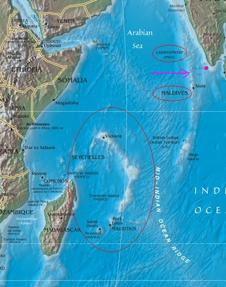
Tamil Land.The arrow points at Kumari Mountain and the red dot Kapadapuram(Kavata).Image Credit jaysreesaranathan blog, Tamizhanthiravidana blog spot.

    Atlantis and Lemuria .jpg
    Atlantis and Lemuria Location.Image credit. alternative research.

    Atlantis Lemuria Location Map.

    Osiris’s son Horus entered into a treaty with Lord Rama to fight against Seth who usurped the Kingdom in Sumeria and Osiris also wanted to check the power of the Lemurians.

    Now Lemuria is called as Kumari Kandam in Tamil Literature and Tamil Literature abounds in Lemuria references.

    Please read my posts on this.

    If Horus and Rama had entered into a pact to defeat Seth and Lemurians, who were Lemurians and in what state had they had been?

    I remembered the description in Tamil of the Kumarikandam especially in the Sangam Literature and their assertion about the city of Kapadapuram, also called as Kavatam.

    ‘According to historians, Kuadam was very close to Tiruchendur. Abraham Pandithar says that Greeks in those days named it as Periplus port’ ( Wiki)

    The Tami land extended from Kapadapuram to Then Madurai.

    The distance is about 7460Kms and the western side the land stretched to Africa!( 700 Katham)

    In this area there were 49 Tamil Kingdoms, called Ezheezh Nadukal( 7*7 countries).

    Adiyarkunallar mentions that the lost land extended from Pahruli river in the north to the Kumari river in the South. It was located to the south of Kanyakumari, and covered an area of 700 kavatam (a unit of unknown measurement). It was divided into 49 territories (natu), classified in the following seven categories:

    • Elu teñku natu (“Seven coconut lands”)
    • Elu Maturai natu (“Seven mango lands”)
    • Elu munpalai natu (“Seven front sandy lands”)
    • Elu pinpalai natu (“Seven back sandy lands”)
    • Elu kunra natu (“Seven hilly lands”)
    • Elu kunakarai natu (“Seven coastal lands”)
    • Elu kurumpanai natu (“Seven dwarf-palm lands”)(wiki)

    Many Tamil Hindu shrines have legendary accounts of surviving the floods mentioned in Hindu mythology. These include the prominent temples of Kanyakumari, Kanchipuram, Kumbakonam, Madurai, Sirkazhi and Tiruvottiyur.[8]:57–69 There are also legends of temples submerged under the sea, such as the Seven Pagodas of Mahabalipuram. The Puranas place the beginning of the most popular Hindu flood myth – the legend of Manu – in South India. The Sanskrit-language Bhagavata Purana (dated 500 BCE-1000 CE) describes its protagonist Manu (aka Satyavrata) as the Lord of Dravida (South India). TheMatsya Purana (dated 250–500 CE) also begins with Manu practicing tapas on Mount Malaya of South India.[8]:57 Manimeghalai (dated around 6th century CE) mentions that the ancient Chola port city of Kavirippumpattinam (present-day Puhar) was destroyed by a flood. It states that this flood was sent by the Hindu deity Indra, because the king forgot to celebrate a festival dedicated to him.

    There are refernces in Atlantis legends that the earth had an inner core populated with people.

    “The first is Mother Earth’s inner crust, which is a continuation of the external surface crust. The two Polar Regions each have a large entrance or hole, somewhat like a cored apple, and the crust wraps itself down and around the mantle into the hollow interior. The outer and inner crusts have very similar topography: Both comprise oceans, continents, mountain ranges, lakes, and rivers. It is merely that the inner crust faces the Earth’s core. This core glows and is surrounded by a cloudy veil. The light given off is more diffuse that the light of the Sun, so the daylight in inner Earth is softer and gentler than on the Earth’s external surface. The second main feature of inner Earth is the so-called cavern worlds. These are immense hollows within the mantle, some of which are natural features created by Mother Earth, while others were made using the advanced technology of inner Earth’s major society, the land of Aghartha. This land is the last living remnant of Earth’s second Galactic Federation colony, Lemuria.

    Lemuria, in her original form, was a surface society with a subterranean component. The primary capital city was situated on the large island that sank beneath the waves of the Pacific some 25,000 years ago. A secondary capital city was located in inner Earth. It was to this city that the government of Lemuria moved after the cataclysm. The new ruler of the surface, the Empire of Atlantis, ordered the major tunnel entrances to be sealed. It was only during the final days of Atlantis that the Lemurians broke these seals and thus saved many surface dwellers from certain death. These people formed a society that subsequently returned for a time to the surface and became the Rama Empire situated in Southern Asia. Then the Great Flood of 8,000 BC ended this attempt to save humanity from the dark ways of the Anunnaki. Despite this setback, Lemuria persisted in her role of protecting the surface world from these havoc-wreaking rapscallions. It was her galactic emissaries that maintained membership for this solar system in the Galactic Federation.

    After the Great Flood and the demise of the Rama Empire, the Lemurians regrouped and named their newly combined society Aghartha. The capital Shamballah was relocated to a cavern located far beneath the city of Lhasa in modern Tibet. Many tunnels connect Shamballah to the surface in the Himalayas. These were used by holy men who came to spread their great energy and divine wisdom to the outside world. In this area, an extraordinary place was kept for special occasions, where holy men and their chosen disciples met in order to maintain Mother Earth’s sacred energy grids. This work, together with numerous rituals performed daily throughout inner Earth, is largely responsible for keeping alive the divine energy that is Lemuria’s main legacy to the surface peoples of Mother Earth. Lemuria, and later on Aghartha, have continuously held the Light for your transformation back into fully conscious Beings of Light.”( Source. http://www.paoweb.com/sn020706.htm)

    The term Kapatam means Window.

    Probably the reference in the Atlantis legend means Kapadapuram when they say Lemurians emerge from the sea.

    The Kapadapuram was established by  a Tamil Pandya King .

    ‘With this loss of the large territories of the Pandiya country and the demise the Paandiya king Kadungkon, the next successor to Paandiyan throne was the king Paandiyan Nediyoan. This king escaped the great disaster and moved more towards the north and captured many new regions including parts of Chera and Chola countries and made them into a new Pandiyan country.

    He distributed the captured lands to his subjects who met the loss of their own lands but possibly escaped this great tragedy, made him get the title “Nilam Tharu Thiruvit Pandiyan” (which means: “the Pandiyan who made the kind gesture of lands”) and as “Nilam Tharu Thiruvit Nediyoan”.

    The Paandiyan king Nediyon built his new capital city at Kapaadapuram (Kavaadam) closer to the sea. The Paandiyan king with a view of preventing further sea disasters had a festival in celeberation for the Sea God, and hence he was known as “Munneer Vilavu Nediyon” (Munner Vilavu = Sea (God) celeberation) and also as “Vadivalamba nintra Paandiyan”.

    He also excavated a new artificial river named “Pahruli Aaru” flowing through the city of Kapaadapuram towards the sea of the Indian Ocean possibly to make the region fertile and self sufficient in water.

    He also re-organised the Second Thamil Sangam at Kapaadapuram and as an initial measure requested the renowned Tamil Poet of the period the Tholkaappianaar to compose a new Tamil Grammer, as the original Tamil Grammer composed during the period of first Thamil Sangam by the great Poet Agaththiyar known as Ahaththiyam, apparently was lost in the great Land Slide in which the first capital city ‘Then Mathurai’ (South Mathurai) also known as “Naan maadak Koodal” went under sea.

    (Source.  http://www.mayyam.com/talk/showthread.php?9994-A-brief-study-on-the-Pandiyas-(Paandiyar)-of-the-quot-Second-Sangam-quot-Period-of-Tamil-Nadu)

    “. The new ruler of the surface, the Empire of Atlantis, ordered the major tunnel entrances to be sealed. It was only during the final days of Atlantis that the Lemurians broke these seals and thus saved many surface dwellers from certain death. These people formed a society that subsequently returned for a time to the surface and became the Rama Empire situated in Southern Asia. Then the Great Flood of 8,000 BC ended this attempt to save humanity from the dark ways of the Anunnaki.”

    The Atlantis people’ sealing the Lemurians’ probably means the Mascarene plateau.

    Lemuria existed south of this plateau, which was consumed by the sea about 6000 years ago.

    The surfacing of Rama dynasty may indicate the fact that Satyavrata Manu ancestor of Rama had migrated to Ayodhya(whose son Ikshvaku founded the Ikshvaku Dynasty) and the subsequent emergence of Lord Rama and His Kingdom.

    One may note that the Ramayana and the Puranas call the Tamil areas as Dravida, meaning South, Dasyu, meaning who do not follow all the percepts of Sanatana Dharma( though they were practicing Sanatana Dharma they were not Fire (Agni) worshipers),and Viswamitra banished his sons to the south directing them to go to the Dasyu Land.

    Normally this area has been taken as stretching from the Vindhyas, but due to the emergence of the Fact about Mascarene Plataeu , the reference may be to Manscarene plateau

    To sum up,

    The Lemurians (Tamils) were in existence during the Ramayana Period,

    Their land was extended to Then Madurai from Kapadapuram.

    They were a part of the Rama Empire,

    the Tamil Timeline is,

    1. Mathivanan, then Chief Editor of the Tamil Etymological Dictionary Project of the Government of Tamilnadu, in 1991 … the following timeline …:ca. 200,000 to 50,000 BC: evolution of “the Tamilian or Homo Dravida”,
      ca. 200,000 to 100,000 BC: beginnings of the Tamil language
      50,000 BC: Kumari Kandam civilisation
      20,000 BC: A lost Tamil culture of the Easter Island which had an advanced civilisation
      16,000 BC: Lemuria submerged
      6087 BC: Second Tamil Sangam established by a Pandya king
      3031 BC: A Chera prince in his wanderings in the Solomon Island saw wild sugarcane and started cultivation in Tamilnadu.
      1780 BC: The Third Tamil Sangam established by a Pandya king
      7th century BC: Tolkappiyam (the earliest extant Tamil grammer)…

    The continent was destroyed by three large floods which wiped out most of the golden civilization with it:

    Source. http://thelostcontinent-kumarikandam.blogspot.in/

    • Inputs welcome.

    Ref.

    http://thamizhan-thiravidana.blogspot.in/2011/03/46-2.html

  • Secret Chambers Ekambareswara Temple Key To Lost Mu Civilization?

    Secret Chambers Ekambareswara Temple Key To Lost Mu Civilization?

    I have been researching into the origins of Shiva worship in the South.

    I have been referring to, apart from  Sanskrit texts, Tamil Texts,Temple architecture and Temple histories of south and north India.

    In this search,I have noticed that there were at least two tsunamis mentioned in the Tamil Classics.

    The great Flood is present in almost all the civilizations of the world.

    And there are more interesting  nuggets of information.

    1.The Sanatna Dharma spread in South East Asia and Westwards of India seem to have been from the South.

    2.Rama’s ancestor Satyavrata Manu migrated from the South to the North and his son Ikshvaku founded the Ikshvaku Dynasty.

    3.The South Asian spread of Santana Dharma seems to have preceded the spread int he west.

    4.The remains of Tamil Culture is found in all the Asian countries , New Zealand and Australia.

    5.The Incas whose ancestors were Tamils and they came later than the Africans.

    6.The ancestors of the Africans, the Olmecs’ ancestors were Tamils from Godavari Kumtis.

    7.This leads to the discrepancy in dating the Tamils and these Cultures.

    8. Once we are able to distinguish between the Two Floods, we can see some light in this search.

    The Southern part of India, below the Deccan Plateau/ Vindhya/Satpura Mountains seems to have separated from the landmass of India twice, one each at each Flood.

    The earliest one formed the Kumari Kandam, which has been referred to by the Tamil Classics.

    This spread was east wards towards reaching to Australia.

    Later came the Lemuria, which had the Atlantis a part of it.

    I have been trying to find the connection between the Mu Civilization and the Tamils.

    Detailed Post on this follows shortly.

    In the meantime I stumbled on some information I thought worth sharing.

    The theory of the Lost Civilization of Mus was floated by James Churchward, a patented inventor, engineer.

    ‘he had found evidence of a lost civilisation: Mu. Mu was said to have been the Pacific equivalent of Atlantis, though Churchward said it was a colony of Mu. The first man to write about Mu was Augustus LePlongeon, who in archaeological circles has the distinction of being the first to make a photographic record of the ruins of Chichen Itza. In his books “Sacred Mysteries Among the Mayans and Quiches” (1886) and “Queen Moo and the Egyptian Sphinx” (1896), LePlongeon related his decipherment of the so-called “Troano Codex”, which he claimed showed that the Maya were the ancestors of the Ancient Egyptians. The Mayans had originated from a lost civilization, Mu, which was on par with Atlantis, and which had been destroyed by a volcanic eruption. He added that Queen Moo – clearly linked with Mu – had travelled from this continent to Egypt, where she had gone down into the history books under her new name of Isis. Unfortunately, when the Mayan language was deciphered several decades later, it was learned that LePlongeon’s interpretation of this document was completely erroneous, sometimes even using letters that were in fact no such thing. Jack Churchward, a descendent of James Churchward, states that LePlongeon relied on the translation of Brasseur de Bourbourg. Jack Churchward received an email from one of de Bourbourg’s descendants, who stated that the translation was done by channelling a spirit, which explains why LePlongeon erred so much when he interpreted the document based on this translation.
    LePlongeon did put the lost civilization of Mu on the books, but left it to Theosophist Helena Blavatsky to popularize the lost continent, claiming it was the mystical birthplace of occult traditions. But the man who brought Mu from theory and speculation to reality was James Churchward, who claimed to have found hard physical evidence for the continent’s existence, when he was shown a secret library in India…

    Chruchward reported that he found manuscripts signifying the connection between the Tamils and the Mus ina secret chamber in Ekambareswarar Temple, Kanchipuram,Tamil Nadu.

    He had found some Tablets too.

    ‘Churchward’s discovery became famous when a major article on it appeared on November 10, 1924 in the “New York American” newspaper. In it, the central framework of Churchward’s claims about Mu was put forward. The civilisation was labelled “Empire of the Sun”. It was once a civilisation that had 64 million inhabitants, known as the Naacals, the priestly brotherhood, keepers of the sacred wisdom, who lived 50,000 years ago. All known ancient civilisations – India, Egypt and the Mayas – were decayed remnants of its many colonies.
    In 1926, at the age of 75, Churchward published “The Lost Continent of Mu: Motherland of Man”. Where was Mu? It extended from north of Hawaii to the Fijis and Easter Island. Geologists find it hard to imagine dry land here, as the area is crossed by the so-called Andesite Line, making it geologically unlikely there was a landmass here. As Churchward never produced any evidence for his visit to the Naacal Library, several people treat his claims with scepticism.
    So was Churchward a liar, or someone with genuine experiences? To understand the man better, it is noted that some aspects of the Mu legend are original to Churchward, some aren’t. It was LePlongeon who had first written about the “Nacaal”, in 1896, where he identifies them as Maya adepts and missionaries, with the word Naacal meaning “the exalted”. But LePlongeon therefore identified their homeland as Central America, not Mu in the Pacific Ocean, which was specific to Churchward.
    What about his relationship with Blavatsky? They both claimed that in India, they had been exposed to “lost knowledge”. In the case of Blavatsky, her source of lost knowledge was the “Book of Dzyan”, supposedly written in Atlantis and presented to her by the Indian Mahatmas.
    Indeed, though it could be argued that Churchward merely copied from the likes of Blavatsky and LePlongeon in his exploit of Mu, at the same time, it could be said that his story is totally true and that it confirms Blavatsky’s assertions and that Churchward spent several decades cementing his case before he went public and wrote his series of books on the subject.
    Churchward was living in India in the 1880s, before he moved to the United States in 1889. It is during his time in India when he allegedly made contact with these Indian adepts – allowing for a period of roughly a decade where he could befriend, learn and study the language – more than sufficient time. Churchward said he studied the language which was said to be Mankind’s original language, which had labelled “Naga-Maya”, for more than two years
    After having read the Naacal documents, he continued his searches for further information. In Burma, he visited an ancient Buddhist temple in search of the missing records, carrying letters of introduction from the Indian high priests with whom he studied…

    ‘His story truly hinges on whether or not he acquainted an Indian priest and saw numerous rare tablets. As a result, for years, the story of Churchward therefore remained a legend, while his books were reprinted. But never, anything new was found that might change the status quo. That changed when the German independent researcher, author and travel agency manager Thomas Ritter claimed he had entered a “secret library” underneath Sri Ekambaranatha temple in Kanchipuram, India in which he has found evidence of the lost civilisation of Mu.
    He claims that on July 23, 2010, he was contacted by one Pachayappa, who invited him to enter the underground complex – and even allowed him to photograph some of its contents! Ritter states how “at chamber no. 4 the priest only allowed me to take pictures from two tablets, not from all this books there. The two tablets he showed me, are a little bit damaged. But you can see clearly the inscriptions.”
    These two tablets are the so-called Naacal tablets, which James Churchward claimed to have seen many decades before. When Ritter published the material, there was immediately a torrent of disbelief, not helped by the realization that what Ritter apparently showed was a tablet unearthed in Byblos (Lebanon), discovered by French archaeologist Maurice Dunand. Because of the small amount of writing on the tablets, they have so far not been deciphered, though the script is identified – Proto-Byblian – and therefore not related to India. Indeed, the tablet presented by Ritter is in the Beirut Museum (Cat. 16598) and not a secret library in India.
    Ritter claims that in July 2010, he was not welcomed by the usual young priest Narjan, whom he knew well, but an elder man, Pachayappa, who unlike Narjan, did not speak English. Pachayappa took him down into the underground structures of the temple complex. Ritter states: “Before an iron-bound door he stopped and pointed with some gesture to the bottom: ‘Rishi place!’” Then he opened the door, behind which the Nacaal library was located.
    Whether Ritter is lying or not, he has at least specifically identified a temple as the location of the library: the Sri Ekambaranatha Temple in Kanchipuram, in the state of Tamil (India). The gate of the temple complex measures more than sixty metres tall, making it the largest temple tower in Southern India, and is made from granite, decorated with the images of gods, goddesses and heroes. The complex is a Hindu temple dedicated to Lord Shiva and is one of the five major Shiva temples, each of which representing a natural element. The Sri Ekambaranatha Temple represents the element earth. The temple’s history dates back to at least 600 AD, though could be older and is notorious for its “hallway with a thousand pillars”, as the temple’s inner walls are decorated with an array of 1,008 Shiva lingams, a symbol of the male energy.
    But Ritter has drawn attention to the subterranean system of this complex, where he claims there are ten chambers. In nine of these chambers, they stored the tablets. Each room measured 25 meters long and 15 meters wide, with the ceiling quite low – he could touch it when he stretched his arm out. Pachayappa claimed that the inscriptions detailed the Rishi Puranas, the lives of the culture bringers of Ancient India. Inside were black granite tables, and there were tens of thousands of stone tablets. Ritter notes that “both sides of such postcard-sized stone tablets engraved with tiny lines were narrow characters covered in an unfamiliar script. Other plates showed fine geometric patterns on running, technical drawings, maps and astronomical images.” When he asked what they contained, he said it was the legacy of the Seven Sages.
    In the first three chambers, the tablets are made from black granite, in the next three from gold. Each golden tablet was fourteen by ten centimeters, and about two to three milimeters thick and were bound like a book.
    In the final three rooms, he found silver and bronze tablets that were hard to read, so Ritter used a handkerchief to polish the tablet, restoring it to its original state.
    Ritter claims he was only allowed to photograph two tablets. All of these chambers have inscriptions, describing the lives and deeds of the rishis, and has produced photographs of these inscriptions.
    The tenth room was located at the end of the corridor. In the middle of the room rose a column of about 1.50 m high from a solid black material, and according to Pachayappa, the material was not stone. Behind the lingam were statues of the Seven Rishis, placed in a semi-circle, and were made from a shimmering metal, which Ritter thought could be gold or silver-plated. One of them he was able to identify as Aghasthiya, who is always depicted as a dwarf.’

    Kanchipuram Residents, please contribute.

    Citations.

    Secret Chamber in Ekambareswarar Temple

    https://ramanisblog.in/2015/07/31/ancestors-of-africans-olmechs-tamils-komati-from-godavari/

  • Kumarikandam, Lemuria Are Not the Same

    While one reads about the lost continents of Lemuria and Kumarikandam, one is likely to assume that both are the same.

    This is due to the hazy impression one gets about the Tsunami that was the cause for the massive upheaval in the south of the Vindhyas, the Dravida Desa.

    Geographical Position of Mu.jpg Geographical Position of Mu.


    Lemuria, Map.jpg hypothetical sketch of the monophyletic origin and extension of the twelve races of Man from Lemuria over Earth.” From Haeckel, Natürliche Schöpfungsgeschichte, Plate XV. Note the differences in the German version (1868) without Lemuria and the English version (1876) with Lemuria, after 1870 Haeckel adopted and promoted the idea of a sunken continent in the Indian Ocean.

    There  (three?) were two Tsunamis mentioned in the Tamil Classics, Silappadikaram, Manimeghalai and Jivaka Chintamani.

    Since there were at least two references to Tsunamis and four references to earth quakes in Sangam Tamil and post Sangam Tamil verses we can be sure of some natural catastrophes. The reason for the doubts about their existence came from the big number of kings, big number of poets they sponsored and the years the kings ruled. If we take those years as exaggerated or coded language then we can reconcile the contradictions.

    Adirakku Nallar, the commentator of Tamil epic Cilappatikaram had given the geography of the Tamil Land that was devoured by the sea. He wrote that there were seven big areas and each one was divided into seven smaller areas. Seven is a sacred number for Hindus and this type of land division is already in Hindu mythologies. When the first Tamil Sangam at South Madurai went into the sea ,they moved south and established the second academy at Kapatapuram. When that was also devoured by the sea they moved further south and established the third Tamil Sangam in modern Madurai. During the second academy Tolkappiyam was written by Tolkappiyar. At present Tolkappiyam  is the oldest available Tamil work, which is grammar book. Scholars date it to first century BC or AD. Some kings and poets who were part of First (Murinjiyur Mudinagarayar) and Second Sangam wrote a few poems which are included in Sangam corpus of Tamil literature ( Panamparar, Kakkaipatiniyar).

    Any student of linguistics will easily find out that their poems were not very old as claimed by the commentator. The language of Tolkappiyam and verses by Muda Thirumaran (King during second Tamil Sangam) and Murinjiyur Mudinagarayar (First Tamil Sangam)betray their age. The language was not very different from other Sangam poems. If we apply the thumb rule followed by Max Muller to date the Vedic literature (two hundred years for language changes) both Tolkappiyam and other Sangam works will be grouped under the same period. Tolkappiyar himself indirectly says that he compiled whatever materials available at that time. He adds in hundreds of places the journalist’s cliché “they say”, “it is said that”. This makes it clear that he was not the one who wrote every bit of the book, but it was only a compilation. If we go by his language we can’t put him back any further than first century. His colleague Panamparar wrote the introduction (prefatory verse) for his treatise. His language was not archaic either.

    The commentator of “Iraiynar Agapporul” gives a full account of the three Tamil Sangams .In the background of this linguistic evidence and in the absence of any historical proof, the claim that the  First Tamil Sangam existed for 4400 years under  89 kings and 4449 poets composed poems wont command any credibility. It is the same story about Second Tamil Sangam which existed for 3750 years  under  59 kings and 3700 poets. The third Tamil Sangam existed for 1850 years.’….

    I am of the opinion that the dates mentioned around 1 Ad or even 5000 BC may not be correct, considering the references one finds about the Tamils in the Vedas,  when Rig-Veda has been dated around 5000 years ago, the date of Tamils should have been pushed earlier.

    Based on the evidence available about the two Tsunamis, it is quite probable, the break of the South, Tamil Nadu could have been in two phases.

    One when Lemuria got disengaged from the Indian Mass.

    The other, Kumarikandam.

    Considering the facts that,

    Manu Precede Daksha,

    This Manu, of Kali Yuga, Satyavrata Manu, migrated from the South to Ayodhya,

    Manu’s are for Manvantaras and hence precede the known history,

    Shiva worship was present in the South even before the Tsunamis,

    The relics of Shiva Ganesha and Murugan are found in the Middle east, Europe, Americas, Russia and Africa,

    Vishnu relics are found in New Zealand and Australia,

    it is probable that these two landmasses  were separated b considerable length of Time.

    I am looking into which one was submerged earlier b referring ti archeological, Astronomical and linguistic evidence from various cultures from the East and West of the Present India.

    Lemuria or Mu is the name of a hypothetical continent that allegedly existed in one of Earth’s oceans, but disappeared at the dawn of human history. The concept and the name were proposed by 19th century traveler and writer Augustus Le Plongeon, (1825-1908), who claimed that several ancient civilizations, such as those of Egypt and Mesoamerica, were created by refugees from Mu – which he located in the Atlantic Ocean. Egypt was founded by Queen Moo, a refugee from the land’s demise. Other refugees supposedly fled to Central America and became the Mayans.

    After his investigations of the Maya ruins in Yucatan, Le Plongeon claimed that he had translated ancient Mayan writings, which supposedly showed that the Maya of Yucatan were older than the civilizations of Greece and Egypt, and additionally told the story of an even older continent. Le Plongeon actually got the name “Mu” from Charles Etienne Brasseur de Bourbourg who in 1864 mistranslated what was then called the Troano Codex using the de Landa alphabet. That was wrong as recent translations of the Troano Codex have shown it to be treaties on astrology. Brasseur believed that a word that he read as Mu referred to a land submerged by a catastrophe. Le Plongeon then identified this lost land with Atlantis, and turned it into a continent which had supposedly sunk into the Atlantic Ocean:..

    Churchward claimed that more than fifty years prior, while he was a soldier in India, he befriended a high-ranking temple priest who showed him a set of ancient “sunburnt” clay tablets, supposedly in a long lost “Naga-Maya language” which only two other people in India could read. Having mastered the language himself, Churchward found out that they originated from “the place where man first appeared – Mu.” The 1931 edition states that “all matter of science in this work are based on translations of two sets of ancient tablets:” the clay tables he read in India, and a collection 2,500 stone tablets that had been uncovered by William Niven in Mexico.

    Churchward gave a vivid description of Mu as the home of an advanced civilization, the Naacal, which flourished between 50,000 and 12,000 years ago, was dominated by a “white race” that was superior in many respects to our own. At the time of its demise, about 12,000 years ago, Mu had 64,000,000 inhabitants and many large cities, and colonies in the other continents.

    Churchward claimed that the landmass of Mu was located in the Pacific Ocean, and stretched east-west from the Marianas to Easter Island, and north-south from Hawaii to Mangaia. He claimed that according to the creation myth he read in the Indian tablets, Mu had been lifted above sea level by the expansion of underground volcanic gases. Eventually Mu was completely obliterated in almost a single night after a series of earthquakes and volcanic eruptions, “the broken land fell into that great abyss of fire” and was covered by “fifty millions of square miles of water.

    Churchward claimed that Mu was the common origin of the great civilizations of Egypt, Greece, Central America, India, Burma and others, including Easter Island, and was in particular the source of ancient megalithic architecture. As evidence for his claims, he pointed to symbols from throughout the world, in which he saw common themes of birds, the relation of the Earth and the sky, and especially the Sun. Churchward claims the king of Mu was Ra and he relates this to the Egyptian god of the sun, Ra, and the Rapanui word for Sun. He claimed to have found symbols of the Sun in Egypt, Babylonia, Peru and all ancient lands and countries – it was a universal symbol.

    Churchward attributed all megalithic art in Polynesia to the people of Mu. He claimed that symbols of the sun are found depicted on stones of Polynesian ruins, such as the stone hats (pukao) on top of the giant moai statues of Easter Island. Citing W.J. Johnson, Churchward describes the cylindrical hats as spheres that seem to show red in the distance, and asserts that they represent the Sun as Ra. He also incorrectly claimed that some of them are made of “red sandstone” which does not occur in the island. The platforms on which the statues rest (ahu) are described by Churchward as being platform-like accumulations of cut and dressed stone, which were supposedly left in their current positions awaiting shipment to some other part of the continent for the building of temples and palaces.He also cites the pillars erected by the Maori of New Zealand as an example of this lost civilization’s art work. In Churchward’s view, the present-day Polynesians are not descendants of the dominant members of the lost civilization of Mu, responsible for these great works, but survivors of the cataclysm that adopted the first cannibalism and savagery in the world.

    Churchward’s Books

    Volume 1The Lost Continent of Mu set out Churchward’s theory utilizing a “vast knowledge of science, ancient art and history, mythology and the occult” to recreate the splendor and doom of this hidden antediluvian world. Lemuria or Mu was about 5,000 miles long and 3,000 miles wide. The Garden of Eden was not in Asia but on a now sunken continent in the Pacific Ocean. The Biblical story of Creation came first not from the peoples of the Nile or the Euphrates Valley but from this now-submerged continent, Mu – the Motherland of Man…

    When ones across the archeological evidence in the areas beig called once belonging to Lemuria, indicate a confirmed Hindu presence and the apread of Tamil culture.

    Kumari Kandam Evidence.

    According to Silappadhikaram, one of the Five Great Epics of Tamil Literature written in 2nd century CE, states that the “cruel sea” took the Pandiyan’s land, part of which was present between the rivers Pahruli and the mountainous banks of the Kumari. These rivers are said to have flowed in a now-submerged land.

    Adiyarkkunallar, a 12th-century CE commentator on the epic, explains this reference by saying that there was once a land to the south of the present-day Kanyakumari, which stretched for 700 kāvatam from the Pahruli river in the north to the Kumari river in the south.
    The modern equivalent of the measurement kāvatam, which is also known as kātam in Tamil, is a distance of 6.25 miles (10.06 km).[

    Kanakkathikaram, a 15th century Tamil Mathematical literary work which is in the form of poems, defines the length of 1 kāvatam(1 kātam) as 24,000 muzham(33,000 feet, 6¼ miles) and it also defines the time taken to cover it which is the distance that can be covered by normal walk in 7½ Nāzhigai or 1 Sāmam(equivalent to 3 hours).
    So, the distance of 700 kāvatam is equivalent to 4,375 miles (7,041 km) in modern day measurements.

    This land was divided into 49 nadu(countries), or territories, which he names as seven coconut territories (elutenga natu), seven Madurai territories (elumaturai natu), seven old sandy territories (elumunpalai natu), seven new sandy territories (elupinpalai natu), seven mountain territories (elukunra natu), seven eastern coastal territories (elukunakarai natu) and seven dwarf-palm territories (elukurumpanai natu).
    All these lands, he says, together with the many-mountained land that began with KumariKollam, with forests and habitations, were submerged by the sea.
    Two of these Nadus or territories were supposedly parts of present-day Kollam and Kanyakumari districts.

    Citations.

    http://www.crystalinks.com/lemuria.html

    https://ramanisblog.in/2015/03/03/lemuria-kumari-kandam-verified-different-landmass/

    http://tamilandvedas.com/2012/03/20/three-tamil-sangams-myth-and-reality-2/

  • Konarak Sun Temple Built By Kulothunga Chola I Descendant

    The inmate  relationship between Sanatana Dharma and Tamils is striking.

    One has been misled into believing that The Tamils had ancestry that was inimical to Hinduism, Sanatana Dharma.

    How wrong could this be!,

    I have written through  many articles including the one that Lord Rama’s ancestor was a Dravidian and he migrated to Ayodhya due a Tsunami in the South of India.

    The ancestry of the two Tamil Dynasties goes back to Solar and Lunar Dynasties, That of Rama and Kauravas.

    Please read my articles on this.

    Sun Temple,Konarak.Image.jpg
    Sun Temple,Konarak,Odisha,India. Image credit.http://en.wikipedia.org/wiki/Konark_Sun_Temple#/media/File:Konark_Temple_Panorama2.jpg
    Konarak Su Dial.Image.jpg
    Koanarak SunDial. The wheels of the chariot are also symbolic and have been interpreted as the ‘Wheel of Life’. They portray the cycle of creation, preservation and achievement of realisation. The diameter of each of the wheels is about nine(2.73 metres) feet and each of them has a set eight equal parts. They are elaborately carved all over. The thicker ones are all carved with circular medallions at their centres on the widest part of the face. The axels of the wheels project by about one foot from the surface, having similar decorations at their ends. The rims are carved with designs of foliages with various birds and animals, whereas the medallions in the spokes are carved with the figures of women in various luxurious poses, mostly of erotic nature. These wheels may also possibly represent the twelve Zodiacs. (src: shreekhetra) – See more at: http://eodisha.org/amazing-odisha-accuracy-sundial-konark-sun-temple-built-1250-d-people-still-use-today-time-konark-sundial-suntemple-india/#sthash.YVHmT0Wb.dpuf

    I am researching on the third Tamil King Dynasty, the Cheras and shall write shortly.

    The Tamil Kings, Cholas and Pandyas were great Devotees of Shiva, Vishnu and Karthikeya, called as Murugan in Tamil Nadu.

    A Chola King had built 101 Shiva Temples along the banks of River Kaveri.

    The Big Temple at Thanjavur ,an architectural marvel was built by Rajaraja Chozhan

    The special type of Vimanas of the temples in India is the contribution og the Tamils to Sanatana Dharma.

    One of the great Temples of India, The Sun Temple at Konarak was built by a descendant of Kulothunga Chola I.

    “Kulothunga Chola I was the grandson of Emperor Rajendra Chola I .As a Chola prince he conquered the Sri Vijaya provinceKedah on behalf of his maternal uncle Emperor Virarajendra Chola in the 11th century. As a Chola Prince he also conqueredBastar in modern Chhattisgarh

    Scroll down for Konarak Video

    Konark Sun Temple was built in Orissa by Chola prince who was daughter of Rajaraja and wife of Vimaladitya.

    The Melakkadambur Shiva temple, built in the form of a chariot during the age of Kulottunga Chola I (1075-1120), is the earliest of this kind, and is still in a well preserved state. It is believed that this temple set the pace for the ratha (chariot) vimana temples in India, as a distant descendant of Kulottunga I on the female line, and thefamous Eastern Ganga ruler Narasimha Deva, built the Sun Temple at Konark in the form of a chariot in the 13th century. Kulottunga Chola is also credited with having built the Suryanaar temple near Kumbhakonam. Temples dedicated to the Sun are not a common feature in the Tamil speaking region of the Indian subcontinent..

    Legend has it that Samba, the king of Krishna and Jambavati entered the bathing chamber of Krishna’s wifes, and was cursed by Krishna with leprosy. It was decreed that he would be relieved of the curse by worshipping the sun God on the sea coast north east of Puri. Accordingly Samba reached Konaditya Kshetra and discovered an image of Surya seated on the lotus, worshipped him and was relieved of his curse.

    It is said that the temple was not completed as conceived because the foundation was not strong enough to bear the weight of the heavy dome. Local beleif has it that it was constructed in entirety, however its magnetic dome caused ships to crash near the seashore, and that the dome was removed and destroyed and that the image of the Sun God was taken to Puri.

    The Temple: The Konark temple is widely known not only for its architectural grandeur but also for the intricacy and profusion of sculptural work. The entire temple has been conceived as a chariot of the sun god with 24 wheels, each about 10 feet in diameter, with a set of spokes and elaborate carvings. Seven horses drag the temple. Two lions guard the entrance, crushing elephants. A flight of steps lead to the main entrance.

    The nata mandir in front of the Jagamohana is also intricately carved.  Around the base of the temple, and up the walls and roof, are carvings in the erotic style.  There are images of animals, foliage, men, warriors on horses and other interesting patterns. There are three images of the Sun God, positioned to catch the rays of the sun at dawn, noon and sunset.

    The Melakkadambur Shiva temple, built in the form of a chariot during  the age of Kulottunga Chola I (1075-1120),  is the earliest of this kind, and is still in a well preserved state.  It is believed that this temple set the pace for the ratha (chariot) vimana temples in India, as a distant descendant of Kulottunga I on the female line, and thefamous Eastern Ganga ruler Narasimha Deva, built the Sun Temple at Konark in the form of a chariot in the 13th century. Kulottunga Chola is also credited with having built the Suryanaar temple near Kumbhakonam. Temples dedicated to the Sun are not a common feature in the Tamil speaking region of the Indian

    The Konarak temple.

    Konark is also known as Konaditya. The name Konark is derived form the words Kona – Corner and Arka – Sun; it is situated on the north eastern corner of Puri or the Chakrakshetra. Konark is also known as Arkakshetra.

    The entire temple is made in the form of a chariot, which symbolizes the carrier of the Sun God. This chariot comprises of 12 magnificent wheels and is drawn by seven fine horses.

    At the entrance of the temple, there are two huge sculptures that show two lions, which are crushing a huge elephant. The Konark Sun Temple, India, also includes a temple known as the Nata Mandir. There are exemplary floral and geometric carvings that adorn the precincts of the Konark Sun Temple, India. The temple continues to amaze the tourists who visit the temple each year. This temple, which worships the Sun God, has been appropriately designed to match the power and aura of the Sun.

    The ruins of this temple were excavated in late 19th century. The tower over the Garbagriha is missing, however the Jagmohana is intact.

    Citation.

    http://veda.wikidot.com/info:konarak-sun-temple

    http://eodisha.org/amazing-odisha-accuracy-sundial-konark-sun-temple-built-1250-d-people-still-use-today-time-konark-sundial-suntemple-india/

  • Indus Valley Harappan Writing Found Hampi Karnataka

    I have often wondered about the antiquity of the South of India,. called Dravida Desa, the Ancient Langauge Tamil which is often quoted by the Vedas and Puranas and tamil Kings being mentioned in the Ithihasaas ,Ramayana and Mahabharata.

    Rig Veda refers to Pearls, Sandalwood,Akhil( a type of Incense wood),Elephants and intricate silk from the Dravida desa,pointing out the Chera Kingdom, now called Kerala, which was once a part of the Tamil Chera Kingdom.

    There is also this reference of Viswamitra banishing his sons to Dravida Desa.

    Their descendant, Apasthamba compiled the Apasthamba Sutra, incorporating Tamil practices into Vedic Culture.

    Indus Valley Harappan Inscrption found in HampiImage.jpg
    Indus Valley Harappan Inscrption found in Hampi,Karnataka.

    Tamil Records show that Lord Krishna attendd the Tamil Poets’ Conclave, He married a Pandyan Princess and had a Daughter through her.

    Arjuna performed Tirta Yatra, Pilgrimage to South and married a Pandyan Princess.

    He had a son through her , Babruvahana, who was the only one to defeat Arjuna and killed him(Arjuna was revived by Krishna)

    Parashurama created what is Now Kerala .

    Balarama visited the Dravida Desa and worshiped Lord Subrahmanya, worshiped there as Murugan.

    Chera King Udiyan Cheralaathan  and another Pandyan King participated in the Kurukshetra War of Mahabharata.

    While Udiyan Ceralaathan fed both the Kaurava and Pandava armies during the war and performed Sraddha for the slain in the Mahabharata war,a Pandyan King Darshak fought on the side of the Pandavas.

    Lord Krishna  fought with a Pandya King and killed him.

    There are references in the Bhavatham and Tamil Classics that during one of the Tsunamis,Satyavrata Manu, the ancestor of Lord Rama migrated to South and his son Ikshvaku founded the Ikshvaku dynasty.

    The Chola Kings trace their Lineage to the Solar Dynasty of Rama and one of their early Kings called Sibi belonged to Ikshvaku Dynasty.

    Mahabharata and Raghuvamsa of Kalidasa record this.

    The archeological finding in Arikkamedu in Pondicherry and a Vedic Homa Kunda is found with references to Vedic Rites in Kanya Kumari dating back to 280BC.

    More archeological finds are reported from Tamil Nadu linking Sanatana Dharma and  the Tamils.

    Tamil Brahmi script was found in Harappa.

    Now comes the startling find.

    Drawings of the Indus Valley Scripts are found in Hampi, Karnataka!


    The writing system of the Indus Valley Civilization is not deciphered and it still remains a mystery. All attempts to decipher it have failed. This is one of the reasons why the Indus Valley Civilization is one of the least known of the important early civilizations of antiquity.

    On the goddess Kotamma temple woollen market way there is a rocky roof shelter for shepherds and sheep to stay at night up to morning.

    The sentence emerged after a set of 19 drawing and pictographs discovered on a hilltop in Hampi (Karnataka, India) were deciphered using root morphemes of Gondi Tribe language.

    Eleven of the Hampi pictographs resemble those of the Indus valley civilisation. This innocuous sounding statement could actually be a revolutionary find linking the Gond or Gondi tribe to the Indus Valley civilisation.

    The Gondi people are a Dravidian people of central India, spread over the states of Madhya Pradesh, eastern Maharashtra (Vidarbha), Chhattisgarh, Uttar Pradesh, Telangana and Western Odisha. With over four million people, they are the largest tribe in Central India.

    “Eleven of the Hampi pictographs resemble the Late Harappan writing of the Indus Valley Civilisation”, says Dr KM Metry, professor of tribal studies at the Kannada University. The professor claims that this shows that after the collapse of the civilisation situated in North-West India, the Harappans moved to other parts of the country, with some of them settling in Central India and a majority of them in the South.”

    My surmise that the Dravida connection with Sanatana Dharma is more deep than considered and may be the Vedic Culture prevailed here along with the Indus Valley civilization, if not earlier.

    * I have noticed a curious fact about Harappa.

    The name Harappa is very differnt from the other Northern town names.

    In fact, as far as my search goes, it is Unique

    Among all the Indian languages,only Tamil has the word ‘Appa’ for Fathere.

    And Shiva was called father in Tamil anitquity and He is addressed as Appan in medieval Tamil literature of the Shaivas and Vaishanava Saint , Azhwar calls Him , Mukkannapa, father with three Eyes!

    Following is the definition of the word Haran, a name for Shiva.

    Intriguing to find Tamil name for God in Harappa!


    ‘ hara—just dissipate    *SB 6.14.57
    hara—please diminish    SB 10.2.40
    hara—the attractor.    Madhya 8.143
    hara—kindly take away    Madhya 20.299
    hara—and Lord Śiva    Madhya 21.36
    hara—plunder    Antya 15.16
    hara—vanquishing    Antya 16.119
    hara—You take away    Antya 16.133

    * Refers to the Puranas or Ithihasas.

    Citation.

    http://www.mysteryofindia.com/2014/12/indus-valley-drawing-discovered-near-hampi.html