Tag: Indian Archeology

  • 5000 Year Dholavira Planned City Water Harvesting Astronomically Aligned

    5000 Year Dholavira Planned City Water Harvesting Astronomically Aligned

    The Ancient History of India is amazing,not merely for the accuracy of facts ,including Geographical but for the skill of the people in building not only temples but well planned cities.

    The myth that early Indians built only temples and were called ‘Barbaric’ these  barbarians built massive temple structures,where the shadow of the building falls in its base,was built in an area where no granite was available,80 tons monolithic block was hoisted at a height of around 180 feet,when pulleys were not supposed to have been known (Thanjavur),

    Temple where the pillar does not rest on the ground,(Lepakshi’

    Where the rays of the Sun fall at a specific time at a specific period;falls at the feet of the Deity..

    There are many temples of this kind.

    There are astronomically aligned temples.

    I have written on most of them.

    Please check under Temples/ Hinduism Category.

    Not only this.

    The ancient Indians built cities in concentric circles with temple at the center,Water tanks,fortification,sewage system,centralised granary,Disaster shelters..

    These were specialized by the Dravida Kings.

    The Kings of North did not lag behind.

    They matched their counterparts in the south.

    Even during Vedic period well planned cities were built.

    Treatise on Town Planning of the Vedic period is found.

    Please read my article on this.

    Now the Harappan period of Dholavira had an advanced town planning system.

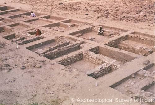
    Excavations at Dholavira,Gujarat,India confirm this.

    The city had,

    16 Gates,

    4 Stadia,

    Water harvesting,

    Drainage system,

    Brick Masonry and Ceramic used.

    The city was built with mathematical precision and

    It was astronomically aligned.


    For details,I am producing excerpts from Archeological Survey of India Report.

    Fourteen field seasons of excavation through an enormous deposit caused by the successive settlements at the site for over 1500 years during all through the 3rd millennium and unto the middle of the 2nd millennium BC have revealed seven significant cultural stages documenting the rise and fall of the Indus civilization in addition to bringing to light a major, a model city which is remarkable for its exquisite planning, monumental structures, aesthetic architecture, amazing water harvesting system and a variety in funerary architecture. It also enjoys the unique distinction of yielding an inscription made up of ten large-sized signs of the Indus script and, not less in importance, is the other find of a fragment of a large slab engraved with three large signs. This paper attempts to give an account of hydro-engineering that is manifest in the structures of the Harappans at Dholavira.

    The ancient site at Dholavira (230 53′ 10″ N; 700 13’E), taluka Bhachau, district Kachchh in state Gujarat, lies in the island of Khadir which, it turn, is surrounded by the salt waste of the Great Rann of Kachchh. The ancient settlement is embraced by two monsoon channels, namely, the Manhar and Mansar. The ruins, including the cemetery covers an area of about 100 hectares half of which is appropriated by the articulately fortified settlement of the Harappans alone.

    Lying between the monsoon channels and being undulating sloping towards the south, the site was ideally suited for a settlement having artificial dams and reservoirs.

    Thee city of Dholavira in its fullest form was a precisely proportionate whole and proportionality resolved configuration following a resolute set of principles of planning and architecture with mathematical precision and, perhaps, with astronomically established orientation. Of the city, at present, three corners with partially eroded towers but fully intact inner corners have been confirmed by excavation. When measured between the inner corners, the E- W length of the city area along the northern defensive wall and N-S one along the western one worked out to 771.10 m and 616.87 m, respectively – thus giving the precise ratio of 5 : 4. Similarly, the other divisions of the city also revealed amazing ratios and proportions. The following table provides revealing information:

     Sl. No.   Division  Width  Length  Ratio
    1 City, internal 616.87 711.10 4 : 5
    2 Castle, internal at available top 92 114 4 : 5
    3 Castle, external (as per present exposure) 118 151 4 : 5
    4 Citadel (castle + bailey), external approximately (including bastions) 140 280 1 : 2
    5 Bailey, internal 120 120 1 : 1
    6 Middle Town + Stadium, internal 290.45 340.5 6 : 7
    7 Middle Town, excluding Stadium, internal 242 340.5 5 : 7
    8 Stadium, internal 47.5 283 1 : 6
    9 Lower Town, built-up area 300 300 1 : 1

    The above table inter alia reveals the proportional relationship between the castle and the city so it does in respect of intra-divisional and inter-divisional measurements. It is interesting to give another illustration: the diagonal drawn between the two opposite angles made by the north-eastern and the south-western corners of the city touched the north-western corner of the castle. While of the remaining two, the south-eastern corner is still missing, or not found out, a line, therefore bisecting the north-western angle also bisected the north-western corner of the middle town and further on cut across a crossing of four streets and finally the north-eastern corner of the castle. This could have been achieved by precise mathematical calculations and drawings which were then translated on the ground that was undulating by 13 m in gradient. It was indeed a great engineering achievement. In the whole scheme, the enwalled area of the castle became 49th (7 X 7) part of the city while its total built-up area was 25th (5 X 5) part.

    Furthermore, it is very significant that the two-thirds of the middle town and the whole of lower town were planned with bold projections and recesses just like those one finds in the layout of an Indian temple of the later ages. As a result, the city divisions were provided with a number of housing sectors and spaces. Some of latter were found to have been used for dumping domestic refuse. Another significant feature is the arterial street that ran across axially from west to east dividing all the above-mentioned units and sub-units into two equal halves, and a north-south street, perhaps somewhat staggered, further subdivided each unit….

    Seventeen gates, all built in the fortification walls with equally interesting add-on components, have been exposed so far. Their number-wise break up is: cattle 5, bailey 2, stadiums 4, middle town 1, annexe 2 and the remaining 3 belonging to the late Harappans of Stage VI. ..

    The other area in which the Harappans of Dholavira excelled spectacularly pertained to water harvesting with the aid of dams, drain, reservoirs and storm water management which eloquently speak of tremendous engineering skill of the builders. Equally important is the fact that all those features were integrated part of city planning and were surely the beauty aids, too, The Harappans created about sixteen or more reservoir of varying sizes and designs and arranged them in a series practically on all four sides. A cursory estimate indicates that the water structures and relevant and related activities accounts for 10 hectares of area, in other words 10% of the total area that the city appropriated within its outer fortification. The 13 m of gradient between high and low areas from east to west within the walls was ideally suited for creating cascading reservoirs which were separated from each other by enormous and broad bunds and yet connected through feeding drains.

    Six of the water tanks, one to east of castle and five of the series to south of it, have been fully or considerably exposed while a few others or other related features are testified in check digs. It was found to be the largest, grandest and best-furnished reservoir of rectangular shape measuring 73.40 m N-S and 29.30 m E-W (ratio 5:2) at the top while above that there should have been a 1 to 1.20 m high embankment as evidenced at four corners.

  • Madurai Dated 3 BC Chess Pieces Roman Coins Found

    What has been touted as legends without basis and figments of imagination is found to be true.

    The Rig Veda has been dated beyond accepted 5000 BC.

    Ancient Chess Pieces at Madurai found.
    Ancient Chess Pieces at Madurai keeladi.

    Dwaraka is about 30, 000 years old..

    Poompuhar, Tamil Nadu is 20,000 years old.

    Million Years old advanced Tamil Site has been found in Chennai.

    Lord Rama is dated at 5114 BC.

    Remains in Madurai of Sangam Age 3 BC
    Sangam Age find, Madurai

    Million year old Kannada Brahmi script was found in Karnataka.

    Sangam artifacts. Porsherd with Tamil Brahmi
    Tamil Brahmi in Potsherds,Madurai, Tamil Nadu.Madurai Sangam artifacts.

    Tamil Brahmi is found in Harappa.

    Madurai, Tamil Nadu has a hoary past.

    Lord Krishna and Arjuna married  Pandyan Princesses at Madurai, had children..

    Lord zkrishna visited Yanai Malai,Elephant Hill near Madurai.

    Madurai is called Moodur in Tamil, meaning old city.

    Vedic people and Greeks/Italians had trade with Madurai.

    The present Madurai is  later one

    Earlier there  was another Madurai, south of the present Madurai, called Then Madurai, South Madurai.

    It was near Madagascar in the Indian Ocean.

    This was here Lord Rama’s ancestor Vaivswatha Manu meditated.

    Rama’s ancestor migrated from here to Ayodhya.

    This city hosted Tamil Poets’ Conclave.

    The city, along with  Huge landmass , Lemuria was inundated by a Tsunami.

    All this sounds pure imagination!

    Please read my articles on each of these by Googling the search term +ramanan50.

    Now there is further evidence that Madurai existed at least by 3 BC.

    Keezhadi ,Madurai. Location
    Keezhadi, Madurai of Sangam age Map,.

    Carbon dating dating is yet to be carried out.

    Archaeologists  opine that it could date back to another 10,000 years back.

    Burnt Bricks used to Build houses, Chess Pieces, Micro Pearls, intricate potteries  were found.

    Archaeological report.

    At Keezhadi, a village not far from the southern bank of the Vaigai river near Madurai, the Archeological Survey of India (ASI) is undertaking a massive excavation, possibly its biggest to date in Tamil Nadu. Already 42 trenches have been dug in two locations in a coconut grove at a place called Pallichandai Thidal in the village. K. Amarnath Ramakrishna, Superintending Archaeologist, ASI’s Excavation Branch VI, Bengaluru, is leading the excavation, which has thrown up quite a few surprises and is attracting many visitors, among them schoolchildren and tourists. Amarnath takes time off to explain to visitors the significance of the finds. One such is a “deep terracotta ring well with 13 rings” that promises to go down further. “Here we have a ring well in association with a structure built of big-sized bricks. This is a peculiarity,” he tells a few visiting archaeology buffs. He contrasts this with the ring well excavated at Vasavasamudram near Kalpakkam (near Chennai), which stood independent of any other structure. The same is the case at Arikkamedu near Puducherry, he adds.

    The structure associated with the well is made of burnt bricks, and the floor is also paved with big bricks. In fact, trench after trench, each five metres long and five metres wide and several metres deep, has structures made of burnt bricks. No mud bricks have been used. One trench features two brick walls, looking imposing and meeting each other. One of the walls is ten bricks thick and set in mud mortar. Each brick is 36 cm long, 24 cm wide and 6 cm thick. Another trench features a rectangular brick structure that looks like an antechamber. Large-sized hand-made grooved tiles have also been found in this trench, suggesting that the structure may have had a tiled roof. One trench has a channel made of bricks, perhaps for releasing water. In most of the trenches, below a certain level, layers of river sand have been found, signalling the existence of paleochannels in the area many centuries ago. There are big storage jars, pots with spouts, twin pots, big decorated pots, black and red pottery, white-painted black ware, and so on, jutting out of the trench walls.

    “It is a fish,” exclaimed one of the children. Vadivel took out artefact after artefact and held them up for the children to see —pearl micro-beads, a big quartz bead with a superb engraving, ivory dices, terracotta human figurines, a copper rod for painting eyelashes, bangles made of conch shells, potsherds with Tamil-Brahmi inscriptions, arretine ware, and shining white-painted black pottery. At the end of it, the children appeared mesmerised. “Were all these that were shown now found here?” asked one of them.

    In fact, all these and more found here point to this being a Sangam Age site. “This is definitely a Tamil Sangam Age site…. It was a habitation site. It was purely a Sangam Age site,” said Amarnath Ramakrishna. What is “impressive” is the discovery of big brick structures in the trenches. “We have got good structures. We have found big-sized walls.” Similar brick structures were found at Arikkamedu, Kancheepuram, Uraiyur, Kaveripoompattinam and Azhagankulam. “On the basis of a comparative study of Keezhadi with these sites and the availability of black and red ware at stratigraphically lower levels, we can say that this site belongs to the 3rd century BCE. This is tentative. We have not done carbon-dating yet,” the Director of Excavation said. The Sangam Age of the Early Historic period is datable from circa 3rd century BCE to 3rd century C.E. Keezhadi derives its importance from its proximity to Madurai, the capital city of the Pandya dynasty. The Pandya kings were known for their patronage in convening assemblies or gatherings, called Sangam, at Madurai, where Tamil literature was composed and compiled…

    had on them the Tamil-Brahmi script. The trenches also yielded black and red ware, Roman arretine ware, rouletted ware, hundreds of beads made of semi-precious stones, ivory dices, iron spearheads and so on. “We have got a rich haul of antiquities. They show the nature of the habitation site of the Tamil Sangam Age and provide evidence about the culture that existed then,” said Vedachalam, who retired as Senior Epigraphist, Tamil Nadu Archaeology Department.

    K. Rajan, Professor of History, Pondicherry University, who visited Keezhadi, also asserted that it was an Early Historic site that had many urban components. “It was one of the urban centres on the Vaigai river basin. It was located between the capital city of Madurai and the port city of Azhagankulam of the Pandya country,” he said. Its urban components were indicated by its civic amenities, external trade, existence of a multi-ethnic society, a communication system, use of luxury items, occurrence of expensive pottery, and so on. The discovery of carnelian beads indicated Keezhadi’s external trade links—the carnelian stone came from Gujarat. Luxury items such as pearl micro-beads and ivory dices showed that the Early Historic residents of Keezhadi had surplus wealth. Potsherds with Tamil-Brahmi inscriptions showed the prevalence of a communication system. While Brahmi was the script used, the language used was both Tamil and Prakrit. The name “Tissa” inscribed in Brahmi script on a potsherd belonged to the Prakrit language. Rajan was sure that the Prakrit name signalled that Keezhadi had maritime trade with Sri Lanka.

    The first season of excavation began on March 2, 2015, and ended in September. Forty-two trenches were dug and, astonishingly, many of them yielded structures made of large-sized bricks that typically belong to the Early Historic period. For instance, a trench dug in the highest point of the mound yielded a massive brick wall. They were all burnt bricks. Another trench yielded a pot with a conical bottom, whose occurrence was rare. Yet another trench yielded a small room built of bricks, whose floor had a spread of river sand. This led to a debate on whether it was a dry toilet. The centre of the mound revealed a lot of structural activity. Small brick-built rooms threw up plenty of pots.

    A bonanza of artefacts was found in almost every trench. What stood out was a big quartz bead with a superbly made engraving. “We can say with confirmation that it was made about 2,200 years ago,” Amarnath Ramakrishna said. “It was found at a depth of 180 cm,” he added. A perforated shallow dish was found as well. “This is a rarity in Tamil Nadu,” he said. Prized discoveries included gleaming pearl micro-beads and hundreds of beads made of semi-precious stones such as carnelian, agate, lapis lazuli and quartz. Glass beads were also found. From the surface of the mound, Vedachalam picked up a human terracotta figurine.

    Other artefacts found in the trenches included shell bangles with decorations, ivory dice incised with concentric circles, terracotta gamesmen and spindle-whorls with iron roads (indicating the existence of a textile industry).

    Amarnath Ramakrishna said: “The artefacts are a confirmation that Keezhadi was a trade centre and that a big town existed there [during the Early Historic period]. Stratigraphically, in the lower levels, we get all the material such as arretine ware, rouletted ware and white-painted black ware which are associated with the Early Historic period. A wealthy, cultured society must have lived there. Stratigraphically, we have found a lot of deposits which offer good evidence to correlate Madurai with the Sangam Age. This site definitely gives a clue to the date of the Sangam Age.”

    Reference and citation.( Text and Images)

    http://www.frontline.in/arts-and-culture/heritage/digging-up-madurais-sangam-past/article8183616.ece

    Chess pieces image credit

    Hindustan Times via.

    http://www.newsgram.com/archaeologists-unearth-remains-of-sangam-age-in-a-city-near-madurai-tamil-nadu/